Owa-Oyibu geodata
Owa-Oyibu (Delta) is a seat of a second-order administrative division; located in Nigeria in Africa/Lagos (GMT+1) time zone. In our database, there are 451 cities with bigger population. Compared to other cities in Nigeria, 81.4% of cities are located further ↑North; 68.2% of cities are located further →East and 67.6% of cities have higher elevation than Owa-Oyibu. Note1


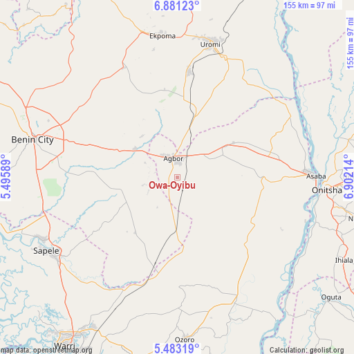
Owa-Oyibu GPS coordinates[2]
6° 10' 57.612" North, 6° 11' 56.472" East
| Map corner | latitude | longitude |
|---|---|---|
| Upper-left | 6.88123°, | 5.49589° |
| Center: | 6.18267°, | 6.19902° |
| Lower-right: | 5.48319°, | 6.90214° |
| Map W x H: | 155.4×155.5 km | = 96.6×96.6mi |
| max Lat: | 13.7543° ⇑81.4% North |
| Owa-Oyibu: | 6.18267° |
| min Lat: | ⇓18.6% South 4.31231° |
| min Long | Owa-Oyibu | max Long |
| 2.73333° | 6.19902° | 14.46552° |
| W 31.8%⇐ | ⇒68.2% E |
Elevation
Elevation of Owa-Oyibu is 159 m = 522 ft, and this is 137.5 m = 451 ft below average elevation for this country.
| Max E: |
1599 m = 5246 ft | 67.6% |
| Avg. | 296.5 m = 973 ft | |
| Owa-Oyibu | 159 m = 522 ft | |
Min E: |
2 m = 7 ft | 32.4% |
See also: Nigeria elevation on elevation.city.
Geographical zone
Owa-Oyibu is located in North Torrid zone (between Equator and Tropic of Cancer). Distance of Equator is 687.4 km =427.1 mi to South.| Distance of | km | miles | from Owa-Oyibu |
|---|---|---|---|
| North Pole | 9319.6 | 5790.9 | to North |
| Arctic Circle | 6713.7 | 4171.7 | to North |
| Tropic Cancer | 1918.5 | 1192.1 | to North |
| Equator | 687.4 | 427.1 | to South |


Nearby cities:
15 places around Owa-Oyibu: (largest is in red/bold)
• Abraka
44.9 km =27.9 mi,  193°
193°
• Abudu
22.5 km =14 mi,  303°
303°
• Agbor
7.9 km =4.9 mi,  356°
356°
• Akwukwu-Igbo
47.5 km =29.5 mi,  65°
65°
• Asaba
58.9 km =36.6 mi,  88°
88°
• Ehor
53.8 km =33.4 mi,  333°
333°
• Idogbo
54.6 km =33.9 mi,  280°
280°
• Igueben
46.9 km =29.1 mi,  5°
5°
• Issele-Uku
34 km =21.1 mi,  64°
64°
• Kwale
58.9 km =36.6 mi,  153°
153°
• Obiaruku
37.7 km =23.4 mi, 187°
• Ogwashi-Uku
36 km =22.4 mi, 90°
• Ubiaja
56.5 km =35.1 mi,  21°
21°
• Umunede
15.3 km =9.5 mi,  53°
53°
• Uromi
59.4 km =36.9 mi, 14°
Sources, notices
• [Note1] Compared only with cities in Nigeria existing in our database
• [Src1] Map data: © OpenStreetMap contributors (CC-BY-SA)
• [Src2] Other city data from geonames.org with taken over terms of usage.
• [Src3] Geographical zone / Annual Mean Temperature by Robert A. Rohde @ Wikipedia
