Amaigbo geodata
Amaigbo (Abia) is a populated place; located in Nigeria in Africa/Lagos (GMT+1) time zone. With population of 127,300 people, there are 66 cities with bigger population in this country. Compared to other cities in Nigeria, 86.4% of cities are located further ↑North; 60.7% of cities are located further ←West and 79.6% of cities have higher elevation than Amaigbo. Note1


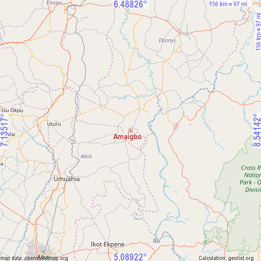
Amaigbo GPS coordinates[2]
5° 47' 21.012" North, 7° 50' 17.844" East
| Map corner | latitude | longitude |
|---|---|---|
| Upper-left | 6.48826°, | 7.13517° |
| Center: | 5.78917°, | 7.83829° |
| Lower-right: | 5.08922°, | 8.54142° |
| Map W x H: | 155.6×155.6 km | = 96.7×96.7mi |
| max Lat: | 13.7543° ⇑86.4% North |
| Amaigbo: | 5.78917° |
| min Lat: | ⇓13.6% South 4.31231° |
| min Long | Amaigbo | max Long |
| 2.73333° | 7.83829° | 14.46552° |
| W 60.7%⇐ | ⇒39.3% E |
Elevation
Elevation of Amaigbo is 84 m = 276 ft, and this is 212.5 m = 697 ft below average elevation for this country.
| Max E: |
1599 m = 5246 ft | 79.6% |
| Avg. | 296.5 m = 973 ft | |
| Amaigbo | 84 m = 276 ft | |
Min E: |
2 m = 7 ft | 20.4% |
See also: Amaigbo elevation on elevation.city.
Geographical zone
Amaigbo is located in North Torrid zone (between Equator and Tropic of Cancer). Distance of Equator is 643.7 km =400 mi to South.| Distance of | km | miles | from Amaigbo |
|---|---|---|---|
| North Pole | 9363.4 | 5818.1 | to North |
| Arctic Circle | 6757.5 | 4198.9 | to North |
| Tropic Cancer | 1962.2 | 1219.3 | to North |
| Equator | 643.7 | 400 | to South |


Nearby cities:
15 places around Amaigbo: (largest is in red/bold)
• Afikpo
15.7 km =9.8 mi,  43°
43°
• Ake-Eze
22.9 km =14.2 mi,  308°
308°
• Akpet Central
34.6 km =21.5 mi,  122°
122°
• Arochukwu
45.2 km =28.1 mi,  169°
169°
• Bende
34.2 km =21.3 mi,  221°
221°
• Ebem Ohafia
17.6 km =10.9 mi,  182°
182°
• Isiaka
33.3 km =20.7 mi,  284°
284°
• Isu
40.3 km =25 mi,  354°
354°
• Itigidi
23.3 km =14.5 mi,  60°
60°
• Mbalano
37.7 km =23.4 mi,  260°
260°
• Ndeaboh
40.4 km =25.1 mi, 312°
• Nguzu Edda
4.4 km =2.7 mi,  211°
211°
• Obiozara
29.5 km =18.3 mi, 345°
• Ohafia-Ifigh
19.6 km =12.2 mi,  188°
188°
• Ugep
26.9 km =16.7 mi,  85°
85°
Sources, notices
• [Note1] Compared only with cities in Nigeria existing in our database
• [Src1] Map data: © OpenStreetMap contributors (CC-BY-SA)
• [Src2] Other city data from geonames.org with taken over terms of usage.
• [Src3] Geographical zone / Annual Mean Temperature by Robert A. Rohde @ Wikipedia
