Mangu geodata
Mangu (Plateau) is a seat of a second-order administrative division; located in Nigeria in Africa/Lagos (GMT+1) time zone. In our database, there are 451 cities with bigger population. Compared to other cities in Nigeria, 59.8% of cities are located further ↓South; 77.5% of cities are located further ←West and 98.9% of cities have lower elevation than Mangu. Note1


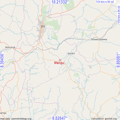
Mangu GPS coordinates[2]
9° 31' 14.16" North, 9° 5' 51.684" East
| Map corner | latitude | longitude |
|---|---|---|
| Upper-left | 10.21332°, | 8.39456° |
| Center: | 9.5206°, | 9.09769° |
| Lower-right: | 8.82647°, | 9.80081° |
| Map W x H: | 154.2×154.2 km | = 95.8×95.8mi |
| max Lat: | 13.7543° ⇑40.2% North |
| Mangu: | 9.5206° |
| min Lat: | ⇓59.8% South 4.31231° |
| min Long | Mangu | max Long |
| 2.73333° | 9.09769° | 14.46552° |
| W 77.5%⇐ | ⇒22.5% E |
Elevation
Elevation of Mangu is 1127 m = 3698 ft, and this is 830.5 m = 2725 ft above average elevation for this country.
| Max E: |
1599 m = 5246 ft | 1.1% |
| Mangu | 1127 m 3698 ft | |
| Avg. | 296.5 m = 973 ft | |
Min E: |
2 m = 7 ft | 98.9% |
See also: Nigeria elevation on elevation.city.
Geographical zone
Mangu is located in North Torrid zone (between Equator and Tropic of Cancer). Distance of Equator is 1058.6 km =657.8 mi to South.| Distance of | km | miles | from Mangu |
|---|---|---|---|
| North Pole | 8948.5 | 5560.3 | to North |
| Arctic Circle | 6342.6 | 3941.1 | to North |
| Tropic Cancer | 1547.3 | 961.4 | to North |
| Equator | 1058.6 | 657.8 | to South |


Nearby cities:
15 places around Mangu: (largest is in red/bold)
• Angware
52.3 km =32.5 mi,  1°
1°
• Barkin Ladi
22.6 km =14 mi,  274°
274°
• Bogoro
58 km =36 mi,  73°
73°
• Boi
44.5 km =27.7 mi,  84°
84°
• Bokkos
27.1 km =16.8 mi,  204°
204°
• Bukuru
39.8 km =24.7 mi,  319°
319°
• Jos
50.6 km =31.4 mi,  333°
333°
• Kwal
59.6 km =37 mi,  106°
106°
• Lere
34 km =21.1 mi,  51°
51°
• Pankshin
42.9 km =26.7 mi,  120°
120°
• Panyam
18 km =11.2 mi,  134°
134°
• Riyom
39.5 km =24.5 mi,  289°
289°
• Tafawa Balewa
56.5 km =35.1 mi,  61°
61°
• Toro
59.9 km =37.2 mi,  357°
357°
• Vom
40.8 km =25.4 mi,  304°
304°
Sources, notices
• [Note1] Compared only with cities in Nigeria existing in our database
• [Src1] Map data: © OpenStreetMap contributors (CC-BY-SA)
• [Src2] Other city data from geonames.org with taken over terms of usage.
• [Src3] Geographical zone / Annual Mean Temperature by Robert A. Rohde @ Wikipedia
