Vom geodata
Vom (Plateau) is a populated place; located in Nigeria in Africa/Lagos (GMT+1) time zone. With population of 12,000 people, there are 296 cities with bigger population in this country. Compared to other cities in Nigeria, 61.5% of cities are located further ↓South; 74.8% of cities are located further ←West and 99.6% of cities have lower elevation than Vom. Note1


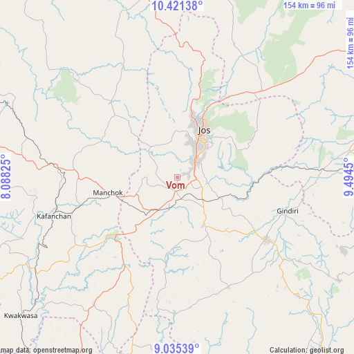
Vom GPS coordinates[2]
9° 43' 44.76" North, 8° 47' 28.968" East
| Map corner | latitude | longitude |
|---|---|---|
| Upper-left | 10.42138°, | 8.08825° |
| Center: | 9.7291°, | 8.79138° |
| Lower-right: | 9.03539°, | 9.4945° |
| Map W x H: | 154.1×154.1 km | = 95.8×95.8mi |
| max Lat: | 13.7543° ⇑38.5% North |
| Vom: | 9.7291° |
| min Lat: | ⇓61.5% South 4.31231° |
| min Long | Vom | max Long |
| 2.73333° | 8.79138° | 14.46552° |
| W 74.8%⇐ | ⇒25.2% E |
Elevation
Elevation of Vom is 1275 m = 4183 ft, and this is 978.5 m = 3210 ft above average elevation for this country.
| Max E: |
1599 m = 5246 ft | 0.40000000000001% |
| Vom | 1275 m 4183 ft | |
| Avg. | 296.5 m = 973 ft | |
Min E: |
2 m = 7 ft | 99.6% |
See also: Nigeria elevation on elevation.city.
Geographical zone
Vom is located in North Torrid zone (between Equator and Tropic of Cancer). Distance of Equator is 1081.8 km =672.2 mi to South.| Distance of | km | miles | from Vom |
|---|---|---|---|
| North Pole | 8925.3 | 5545.9 | to North |
| Arctic Circle | 6319.4 | 3926.7 | to North |
| Tropic Cancer | 1524.1 | 947 | to North |
| Equator | 1081.8 | 672.2 | to South |


Nearby cities:
15 places around Vom: (largest is in red/bold)
• Angware
45.3 km =28.1 mi,  49°
49°
• Barkin Ladi
24 km =14.9 mi,  152°
152°
• Bassa
24.4 km =15.2 mi,  346°
346°
• Bokkos
52.7 km =32.7 mi, 154°
• Bukuru
10.7 km =6.6 mi, 47°
• Jos
24.8 km =15.4 mi,  26°
26°
• Kafanchan
57.1 km =35.5 mi,  253°
253°
• Kagoro
46 km =28.6 mi, 252°
• Kaura
37.1 km =23.1 mi,  259°
259°
• Lere
60.2 km =37.4 mi,  91°
91°
• Mangu
40.8 km =25.4 mi,  124°
124°
• Panyam
58.6 km =36.4 mi,  127°
127°
• Riyom
10.9 km =6.8 mi,  200°
200°
• Toro
47.6 km =29.6 mi,  39°
39°
• Zonkwa
55.2 km =34.3 mi,  276°
276°
Sources, notices
• [Note1] Compared only with cities in Nigeria existing in our database
• [Src1] Map data: © OpenStreetMap contributors (CC-BY-SA)
• [Src2] Other city data from geonames.org with taken over terms of usage.
• [Src3] Geographical zone / Annual Mean Temperature by Robert A. Rohde @ Wikipedia
