Pankshin geodata
Pankshin (Plateau) is a seat of a second-order administrative division; located in Nigeria in Africa/Lagos (GMT+1) time zone. With population of 31,516 people, there are 161 cities with bigger population in this country. Compared to other cities in Nigeria, 58% of cities are located further ↓South; 79.9% of cities are located further ←West and 99.4% of cities have lower elevation than Pankshin. Note1


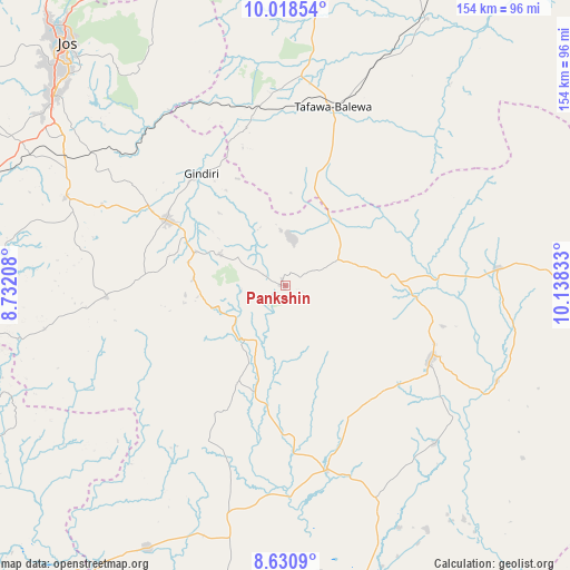
Pankshin GPS coordinates[2]
9° 19' 31.476" North, 9° 26' 6.72" East
| Map corner | latitude | longitude |
|---|---|---|
| Upper-left | 10.01854°, | 8.73208° |
| Center: | 9.32541°, | 9.4352° |
| Lower-right: | 8.6309°, | 10.13833° |
| Map W x H: | 154.3×154.3 km | = 95.9×95.9mi |
| max Lat: | 13.7543° ⇑42% North |
| Pankshin: | 9.32541° |
| min Lat: | ⇓58% South 4.31231° |
| min Long | Pankshin | max Long |
| 2.73333° | 9.4352° | 14.46552° |
| W 79.9%⇐ | ⇒20.1% E |
Elevation
Elevation of Pankshin is 1235 m = 4052 ft, and this is 938.5 m = 3079 ft above average elevation for this country.
| Max E: |
1599 m = 5246 ft | 0.59999999999999% |
| Pankshin | 1235 m 4052 ft | |
| Avg. | 296.5 m = 973 ft | |
Min E: |
2 m = 7 ft | 99.4% |
See also: Nigeria elevation on elevation.city.
Geographical zone
Pankshin is located in North Torrid zone (between Equator and Tropic of Cancer). Distance of Equator is 1036.9 km =644.3 mi to South.| Distance of | km | miles | from Pankshin |
|---|---|---|---|
| North Pole | 8970.2 | 5573.8 | to North |
| Arctic Circle | 6364.3 | 3954.6 | to North |
| Tropic Cancer | 1569 | 974.9 | to North |
| Equator | 1036.9 | 644.3 | to South |


Nearby cities:
15 places around Pankshin: (largest is in red/bold)
• Amper
29.4 km =18.3 mi,  83°
83°
• Baap
47.5 km =29.5 mi,  206°
206°
• Bogoro
42.5 km =26.4 mi,  26°
26°
• Boi
27.2 km =16.9 mi,  15°
15°
• Bokkos
48.4 km =30.1 mi,  266°
266°
• Dengi
58 km =36 mi,  85°
85°
• Kwal
20.8 km =12.9 mi, 75°
• Kwolla
49.5 km =30.8 mi,  198°
198°
• Langtang
44.1 km =27.4 mi,  117°
117°
• Lere
44.1 km =27.4 mi,  346°
346°
• Mangu
42.9 km =26.7 mi,  300°
300°
• Panyam
25.8 km =16 mi,  290°
290°
• Shendam
50.9 km =31.6 mi,  167°
167°
• Tafawa Balewa
50 km =31.1 mi,  14°
14°
• Tunkus
39.1 km =24.3 mi,  149°
149°
Sources, notices
• [Note1] Compared only with cities in Nigeria existing in our database
• [Src1] Map data: © OpenStreetMap contributors (CC-BY-SA)
• [Src2] Other city data from geonames.org with taken over terms of usage.
• [Src3] Geographical zone / Annual Mean Temperature by Robert A. Rohde @ Wikipedia
