Misau geodata
Misau (Bauchi) is a seat of a second-order administrative division; located in Nigeria in Africa/Lagos (GMT+1) time zone. With population of 13,957 people, there are 258 cities with bigger population in this country. Compared to other cities in Nigeria, 75.4% of cities are located further ↓South; 87.2% of cities are located further ←West and 75.6% of cities have lower elevation than Misau. Note1


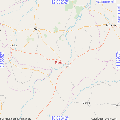
Misau GPS coordinates[2]
11° 18' 49.32" North, 10° 27' 59.904" East
| Map corner | latitude | longitude |
|---|---|---|
| Upper-left | 12.00232°, | 9.76352° |
| Center: | 11.3137°, | 10.46664° |
| Lower-right: | 10.62342°, | 11.16977° |
| Map W x H: | 153.3×153.3 km | = 95.3×95.3mi |
| max Lat: | 13.7543° ⇑24.6% North |
| Misau: | 11.3137° |
| min Lat: | ⇓75.4% South 4.31231° |
| min Long | Misau | max Long |
| 2.73333° | 10.46664° | 14.46552° |
| W 87.2%⇐ | ⇒12.8% E |
Elevation
Elevation of Misau is 436 m = 1430 ft, and this is 139.5 m = 458 ft above average elevation for this country.
| Max E: |
1599 m = 5246 ft | 24.4% |
| Misau | 436 m 1430 ft | |
| Avg. | 296.5 m = 973 ft | |
Min E: |
2 m = 7 ft | 75.6% |
See also: Nigeria elevation on elevation.city.
Geographical zone
Misau is located in North Torrid zone (between Equator and Tropic of Cancer). Distance of Equator is 1258 km =781.7 mi to South.| Distance of | km | miles | from Misau |
|---|---|---|---|
| North Pole | 8749.1 | 5436.4 | to North |
| Arctic Circle | 6143.2 | 3817.2 | to North |
| Tropic Cancer | 1348 | 837.6 | to North |
| Equator | 1258 | 781.7 | to South |


Nearby cities:
15 places around Misau: (largest is in red/bold)
• Azare
50.2 km =31.2 mi,  323°
323°
• Dambam
48.4 km =30.1 mi,  32°
32°
• Darazo
35.5 km =22.1 mi,  189°
189°
• Disina
62.5 km =38.8 mi,  287°
287°
• Dukku
63.9 km =39.7 mi,  148°
148°
• Gabarin
22.9 km =14.2 mi, 186°
• Giade
30.3 km =18.8 mi, 286°
• Gwaram
63.7 km =39.6 mi,  266°
266°
• Jama’are
70.8 km =44 mi,  304°
304°
• Kari
12.7 km =7.9 mi,  125°
125°
• Madara
51.9 km =32.2 mi,  357°
357°
• Sade
23.1 km =14.4 mi,  77°
77°
• Yana
50.5 km =31.4 mi,  281°
281°
• Yanda Bayo
37.3 km =23.2 mi,  54°
54°
• Zadawa
18.6 km =11.6 mi, 324°
Sources, notices
• [Note1] Compared only with cities in Nigeria existing in our database
• [Src1] Map data: © OpenStreetMap contributors (CC-BY-SA)
• [Src2] Other city data from geonames.org with taken over terms of usage.
• [Src3] Geographical zone / Annual Mean Temperature by Robert A. Rohde @ Wikipedia
