Madara geodata
Madara (Bauchi) is a populated place; located in Nigeria in Africa/Lagos (GMT+1) time zone. With population of 10,015 people, there are 333 cities with bigger population in this country. Compared to other cities in Nigeria, 81.5% of cities are located further ↓South; 87% of cities are located further ←West and 68.8% of cities have lower elevation than Madara. Note1


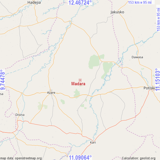
Madara GPS coordinates[2]
11° 46' 47.28" North, 10° 26' 52.44" East
| Map corner | latitude | longitude |
|---|---|---|
| Upper-left | 12.46724°, | 9.74478° |
| Center: | 11.7798°, | 10.4479° |
| Lower-right: | 11.09064°, | 11.15103° |
| Map W x H: | 153.1×153.1 km | = 95.1×95.1mi |
| max Lat: | 13.7543° ⇑18.5% North |
| Madara: | 11.7798° |
| min Lat: | ⇓81.5% South 4.31231° |
| min Long | Madara | max Long |
| 2.73333° | 10.4479° | 14.46552° |
| W 87%⇐ | ⇒13% E |
Elevation
Elevation of Madara is 392 m = 1286 ft, and this is 95.5 m = 313 ft above average elevation for this country.
| Max E: |
1599 m = 5246 ft | 31.2% |
| Madara | 392 m 1286 ft | |
| Avg. | 296.5 m = 973 ft | |
Min E: |
2 m = 7 ft | 68.8% |
See also: Nigeria elevation on elevation.city.
Geographical zone
Madara is located in North Torrid zone (between Equator and Tropic of Cancer). Distance of this Northern Tropic circle is 1296.1 km =805.4 mi to North.| Distance of | km | miles | from Madara |
|---|---|---|---|
| North Pole | 8697.3 | 5404.2 | to North |
| Arctic Circle | 6091.4 | 3785 | to North |
| Tropic Cancer | 1296.1 | 805.4 | to North |
| Equator | 1309.8 | 813.9 | to South |


Nearby cities:
15 places around Madara: (largest is in red/bold)
• Azare
30.3 km =18.8 mi,  247°
247°
• Dambam
30.4 km =18.9 mi,  111°
111°
• Disina
66.5 km =41.3 mi,  240°
240°
• Gamawa
40.6 km =25.2 mi,  13°
13°
• Giade
51 km =31.7 mi,  211°
211°
• Itas
53.4 km =33.2 mi,  279°
279°
• Jama’are
57.9 km =36 mi,  257°
257°
• Kari
60.5 km =37.6 mi,  168°
168°
• Katagum
57.2 km =35.5 mi,  349°
349°
• Misau
51.9 km =32.2 mi,  177°
177°
• Sabon Garin Nangere
68.5 km =42.6 mi,  83°
83°
• Sade
52.8 km =32.8 mi,  152°
152°
• Yana
62.9 km =39.1 mi,  228°
228°
• Yanda Bayo
44.4 km =27.6 mi,  133°
133°
• Zadawa
37.8 km =23.5 mi,  193°
193°
Sources, notices
• [Note1] Compared only with cities in Nigeria existing in our database
• [Src1] Map data: © OpenStreetMap contributors (CC-BY-SA)
• [Src2] Other city data from geonames.org with taken over terms of usage.
• [Src3] Geographical zone / Annual Mean Temperature by Robert A. Rohde @ Wikipedia
