Dankama geodata
Dankama (Katsina) is a populated place; located in Nigeria in Africa/Lagos (GMT+1) time zone. With population of 6,531 people, there are 430 cities with bigger population in this country. Compared to other cities in Nigeria, 99.2% of cities are located further ↓South; 59.6% of cities are located further ←West and 72% of cities have lower elevation than Dankama. Note1


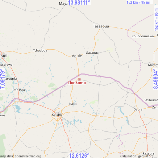
Dankama GPS coordinates[2]
13° 17' 52.152" North, 7° 47' 41.712" East
| Map corner | latitude | longitude |
|---|---|---|
| Upper-left | 13.98111°, | 7.09179° |
| Center: | 13.29782°, | 7.79492° |
| Lower-right: | 12.6126°, | 8.49804° |
| Map W x H: | 152.2×152.2 km | = 94.6×94.6mi |
| max Lat: | 13.7543° ⇑0.8% North |
| Dankama: | 13.29782° |
| min Lat: | ⇓99.2% South 4.31231° |
| min Long | Dankama | max Long |
| 2.73333° | 7.79492° | 14.46552° |
| W 59.6%⇐ | ⇒40.4% E |
Elevation
Elevation of Dankama is 414 m = 1358 ft, and this is 117.5 m = 385 ft above average elevation for this country.
| Max E: |
1599 m = 5246 ft | 28% |
| Dankama | 414 m 1358 ft | |
| Avg. | 296.5 m = 973 ft | |
Min E: |
2 m = 7 ft | 72% |
See also: Nigeria elevation on elevation.city.
Geographical zone
Dankama is located in North Torrid zone (between Equator and Tropic of Cancer). Distance of this Northern Tropic circle is 1127.3 km =700.5 mi to North.| Distance of | km | miles | from Dankama |
|---|---|---|---|
| North Pole | 8528.5 | 5299.4 | to North |
| Arctic Circle | 5922.6 | 3680.1 | to North |
| Tropic Cancer | 1127.3 | 700.5 | to North |
| Equator | 1478.6 | 918.8 | to South |


Nearby cities:
15 places around Dankama: (largest is in red/bold)
• Batagarawa
48.1 km =29.9 mi,  205°
205°
• Bindawa
69.8 km =43.4 mi,  178°
178°
• Charanchi
70 km =43.5 mi,  185°
185°
• Daura
64.4 km =40 mi,  117°
117°
• Dutsi
64.2 km =39.9 mi,  144°
144°
• Jibia
65.6 km =40.8 mi,  249°
249°
• Kaita
24.5 km =15.2 mi, 193°
• Katsina
40 km =24.9 mi, 211°
• Kurfi
77.8 km =48.3 mi, 205°
• Mai’Adua
48.9 km =30.4 mi,  105°
105°
• Mani
50.1 km =31.1 mi,  169°
169°
• Mashi
38.9 km =24.2 mi,  154°
154°
• Rimi
50.6 km =31.4 mi, 190°
• Ruma
77.6 km =48.2 mi,  231°
231°
• Sandamu
71.7 km =44.6 mi, 121°
Sources, notices
• [Note1] Compared only with cities in Nigeria existing in our database
• [Src1] Map data: © OpenStreetMap contributors (CC-BY-SA)
• [Src2] Other city data from geonames.org with taken over terms of usage.
• [Src3] Geographical zone / Annual Mean Temperature by Robert A. Rohde @ Wikipedia
