Mai’Adua geodata
Mai’Adua (Katsina) is a seat of a second-order administrative division; located in Nigeria in Africa/Lagos (GMT+1) time zone. In our database, there are 451 cities with bigger population. Compared to other cities in Nigeria, 98.6% of cities are located further ↓South; 67.2% of cities are located further ←West and 80.4% of cities have lower elevation than Mai’Adua. Note1


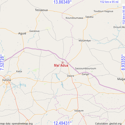
Mai’Adua GPS coordinates[2]
13° 10' 47.496" North, 8° 13' 49.44" East
| Map corner | latitude | longitude |
|---|---|---|
| Upper-left | 13.86349°, | 7.52728° |
| Center: | 13.17986°, | 8.2304° |
| Lower-right: | 12.49431°, | 8.93353° |
| Map W x H: | 152.2×152.2 km | = 94.6×94.6mi |
| max Lat: | 13.7543° ⇑1.4% North |
| Mai’Adua: | 13.17986° |
| min Lat: | ⇓98.6% South 4.31231° |
| min Long | Mai’Adua | max Long |
| 2.73333° | 8.2304° | 14.46552° |
| W 67.2%⇐ | ⇒32.8% E |
Elevation
Elevation of Mai’Adua is 474 m = 1555 ft, and this is 177.5 m = 582 ft above average elevation for this country.
| Max E: |
1599 m = 5246 ft | 19.6% |
| Mai’Adua | 474 m 1555 ft | |
| Avg. | 296.5 m = 973 ft | |
Min E: |
2 m = 7 ft | 80.4% |
See also: Nigeria elevation on elevation.city.
Geographical zone
Mai’Adua is located in North Torrid zone (between Equator and Tropic of Cancer). Distance of this Northern Tropic circle is 1140.5 km =708.7 mi to North.| Distance of | km | miles | from Mai’Adua |
|---|---|---|---|
| North Pole | 8541.6 | 5307.5 | to North |
| Arctic Circle | 5935.7 | 3688.3 | to North |
| Tropic Cancer | 1140.5 | 708.7 | to North |
| Equator | 1465.5 | 910.6 | to South |


Nearby cities:
15 places around Mai’Adua: (largest is in red/bold)
• Baure
67.5 km =41.9 mi,  124°
124°
• Dankama
48.9 km =30.4 mi,  285°
285°
• Daura
19.2 km =11.9 mi,  148°
148°
• Dutsi
40.3 km =25 mi,  194°
194°
• Gwiwa
45.8 km =28.5 mi,  165°
165°
• Ingawa
62.9 km =39.1 mi,  197°
197°
• Kaita
54.1 km =33.6 mi,  258°
258°
• Karkarna
55 km =34.2 mi, 146°
• Kazaure
62.3 km =38.7 mi,  161°
161°
• Mani
52.8 km =32.8 mi,  226°
226°
• Mashi
37.9 km =23.5 mi, 234°
• Rimi
67.3 km =41.8 mi,  236°
236°
• Roni
58.1 km =36.1 mi,  176°
176°
• Sandamu
28 km =17.4 mi, 149°
• Zango
31 km =19.3 mi, 117°
Sources, notices
• [Note1] Compared only with cities in Nigeria existing in our database
• [Src1] Map data: © OpenStreetMap contributors (CC-BY-SA)
• [Src2] Other city data from geonames.org with taken over terms of usage.
• [Src3] Geographical zone / Annual Mean Temperature by Robert A. Rohde @ Wikipedia
