Gamawa geodata
Gamawa (Bauchi) is a seat of a second-order administrative division; located in Nigeria in Africa/Lagos (GMT+1) time zone. With population of 13,549 people, there are 264 cities with bigger population in this country. Compared to other cities in Nigeria, 85.9% of cities are located further ↓South; 87.3% of cities are located further ←West and 64.1% of cities have lower elevation than Gamawa. Note1


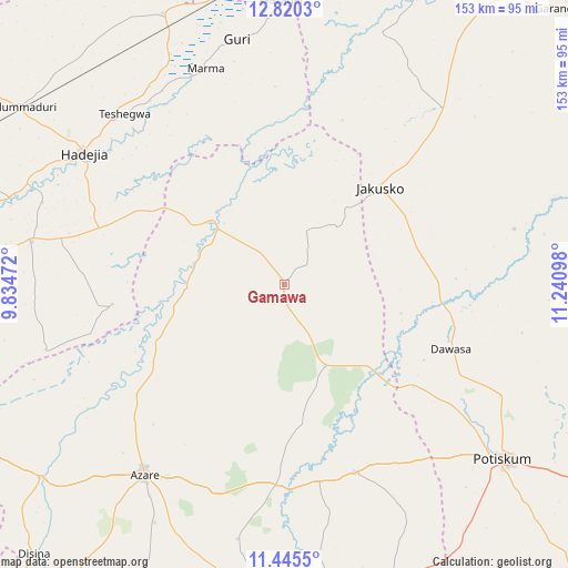
Gamawa GPS coordinates[2]
12° 8' 1.644" North, 10° 32' 16.26" East
| Map corner | latitude | longitude |
|---|---|---|
| Upper-left | 12.8203°, | 9.83472° |
| Center: | 12.13379°, | 10.53785° |
| Lower-right: | 11.4455°, | 11.24098° |
| Map W x H: | 152.9×152.9 km | = 95×95mi |
| max Lat: | 13.7543° ⇑14.1% North |
| Gamawa: | 12.13379° |
| min Lat: | ⇓85.9% South 4.31231° |
| min Long | Gamawa | max Long |
| 2.73333° | 10.53785° | 14.46552° |
| W 87.3%⇐ | ⇒12.7% E |
Elevation
Elevation of Gamawa is 364 m = 1194 ft, and this is 67.5 m = 221 ft above average elevation for this country.
| Max E: |
1599 m = 5246 ft | 35.9% |
| Gamawa | 364 m 1194 ft | |
| Avg. | 296.5 m = 973 ft | |
Min E: |
2 m = 7 ft | 64.1% |
See also: Nigeria elevation on elevation.city.
Geographical zone
Gamawa is located in North Torrid zone (between Equator and Tropic of Cancer). Distance of this Northern Tropic circle is 1256.8 km =780.9 mi to North.| Distance of | km | miles | from Gamawa |
|---|---|---|---|
| North Pole | 8657.9 | 5379.8 | to North |
| Arctic Circle | 6052 | 3760.5 | to North |
| Tropic Cancer | 1256.8 | 780.9 | to North |
| Equator | 1349.2 | 838.4 | to South |


Nearby cities:
15 places around Gamawa: (largest is in red/bold)
• Auyo
68.8 km =42.8 mi,  288°
288°
• Azare
63.5 km =39.5 mi,  216°
216°
• Dambam
53.9 km =33.5 mi,  159°
159°
• Gorgoram
59.1 km =36.7 mi,  17°
17°
• Guri
67.3 km =41.8 mi,  349°
349°
• Hadejia
64.6 km =40.1 mi,  303°
303°
• Itas
69.6 km =43.2 mi,  243°
243°
• Jakusko
36.8 km =22.9 mi,  44°
44°
• Kafin Hausa
69.1 km =42.9 mi,  279°
279°
• Katagum
26.4 km =16.4 mi,  309°
309°
• Kiri Kasamma
69.3 km =43.1 mi,  333°
333°
• Madara
40.6 km =25.2 mi,  193°
193°
• Potiskum
75.3 km =46.8 mi,  128°
128°
• Sabon Garin Nangere
66.3 km =41.2 mi,  118°
118°
• Yanda Bayo
73.3 km =45.5 mi, 161°
Sources, notices
• [Note1] Compared only with cities in Nigeria existing in our database
• [Src1] Map data: © OpenStreetMap contributors (CC-BY-SA)
• [Src2] Other city data from geonames.org with taken over terms of usage.
• [Src3] Geographical zone / Annual Mean Temperature by Robert A. Rohde @ Wikipedia
