Benisheikh geodata
Benisheikh (Borno) is a seat of a second-order administrative division; located in Nigeria in Africa/Lagos (GMT+1) time zone. With population of 9,825 people, there are 337 cities with bigger population in this country. Compared to other cities in Nigeria, 82% of cities are located further ↓South; 95.8% of cities are located further ←West and 60.9% of cities have lower elevation than Benisheikh. Note1


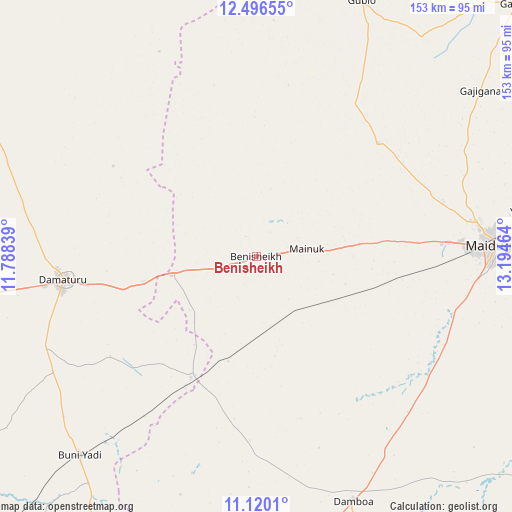
Benisheikh GPS coordinates[2]
11° 48' 33.084" North, 12° 29' 29.436" East
| Map corner | latitude | longitude |
|---|---|---|
| Upper-left | 12.49655°, | 11.78839° |
| Center: | 11.80919°, | 12.49151° |
| Lower-right: | 11.1201°, | 13.19464° |
| Map W x H: | 153×153.1 km | = 95.1×95.1mi |
| max Lat: | 13.7543° ⇑18% North |
| Benisheikh: | 11.80919° |
| min Lat: | ⇓82% South 4.31231° |
| min Long | Benisheikh | max Long |
| 2.73333° | 12.49151° | 14.46552° |
| W 95.8%⇐ | ⇒4.2% E |
Elevation
Elevation of Benisheikh is 351 m = 1152 ft, and this is 54.5 m = 179 ft above average elevation for this country.
| Max E: |
1599 m = 5246 ft | 39.1% |
| Benisheikh | 351 m 1152 ft | |
| Avg. | 296.5 m = 973 ft | |
Min E: |
2 m = 7 ft | 60.9% |
See also: Nigeria elevation on elevation.city.
Geographical zone
Benisheikh is located in North Torrid zone (between Equator and Tropic of Cancer). Distance of this Northern Tropic circle is 1292.9 km =803.4 mi to North.| Distance of | km | miles | from Benisheikh |
|---|---|---|---|
| North Pole | 8694 | 5402.2 | to North |
| Arctic Circle | 6088.1 | 3783 | to North |
| Tropic Cancer | 1292.9 | 803.4 | to North |
| Equator | 1313.1 | 815.9 | to South |


Nearby cities:
15 places around Benisheikh: (largest is in red/bold)
• Babban Gida
87.3 km =54.2 mi,  296°
296°
• Bornu Yassu
52.5 km =32.6 mi,  9°
9°
• Buni Yadi
79.4 km =49.3 mi,  221°
221°
• Damaturu
58.2 km =36.2 mi,  263°
263°
• Damboa
78.2 km =48.6 mi,  158°
158°
• Dankalwa
34.1 km =21.2 mi, 257°
• Gajiram
109 km =67.7 mi,  45°
45°
• Goniri
41 km =25.5 mi,  208°
208°
• Gubio
82.7 km =51.4 mi,  22°
22°
• Gujba
69.8 km =43.4 mi,  240°
240°
• Khaddamari
81.5 km =50.6 mi,  80°
80°
• Konduga
102.3 km =63.6 mi,  99°
99°
• Magumeri
49.8 km =30.9 mi, 47°
• Maiduguri
72.6 km =45.1 mi,  86°
86°
• Yajiwa
53.2 km =33.1 mi,  152°
152°
Sources, notices
• [Note1] Compared only with cities in Nigeria existing in our database
• [Src1] Map data: © OpenStreetMap contributors (CC-BY-SA)
• [Src2] Other city data from geonames.org with taken over terms of usage.
• [Src3] Geographical zone / Annual Mean Temperature by Robert A. Rohde @ Wikipedia
