Kafin Hausa geodata
Kafin Hausa (Jigawa) is a seat of a second-order administrative division; located in Nigeria in Africa/Lagos (GMT+1) time zone. With population of 12,609 people, there are 283 cities with bigger population in this country. Compared to other cities in Nigeria, 87.5% of cities are located further ↓South; 83.6% of cities are located further ←West and 64.1% of cities have lower elevation than Kafin Hausa. Note1


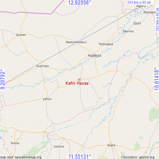
Kafin Hausa GPS coordinates[2]
12° 14' 21.588" North, 9° 54' 39.78" East
| Map corner | latitude | longitude |
|---|---|---|
| Upper-left | 12.92556°, | 9.20792° |
| Center: | 12.23933°, | 9.91105° |
| Lower-right: | 11.55131°, | 10.61418° |
| Map W x H: | 152.8×152.8 km | = 94.9×94.9mi |
| max Lat: | 13.7543° ⇑12.5% North |
| Kafin Hausa: | 12.23933° |
| min Lat: | ⇓87.5% South 4.31231° |
| min Long | Kafin Hausa | max Long |
| 2.73333° | 9.91105° | 14.46552° |
| W 83.6%⇐ | ⇒16.4% E |
Elevation
Elevation of Kafin Hausa is 364 m = 1194 ft, and this is 67.5 m = 221 ft above average elevation for this country.
| Max E: |
1599 m = 5246 ft | 35.9% |
| Kafin Hausa | 364 m 1194 ft | |
| Avg. | 296.5 m = 973 ft | |
Min E: |
2 m = 7 ft | 64.1% |
See also: Nigeria elevation on elevation.city.
Geographical zone
Kafin Hausa is located in North Torrid zone (between Equator and Tropic of Cancer). Distance of this Northern Tropic circle is 1245 km =773.6 mi to North.| Distance of | km | miles | from Kafin Hausa |
|---|---|---|---|
| North Pole | 8646.2 | 5372.5 | to North |
| Arctic Circle | 6040.3 | 3753.3 | to North |
| Tropic Cancer | 1245 | 773.6 | to North |
| Equator | 1360.9 | 845.6 | to South |


Nearby cities:
15 places around Kafin Hausa: (largest is in red/bold)
• Auyo
10.9 km =6.8 mi,  16°
16°
• Gagarawa
45.6 km =28.3 mi,  294°
294°
• Gantsa
67.1 km =41.7 mi,  197°
197°
• Hadejia
27.7 km =17.2 mi,  30°
30°
• Itas
42.8 km =26.6 mi,  172°
172°
• Jahun
35.8 km =22.2 mi,  239°
239°
• Jama’are
63.4 km =39.4 mi,  178°
178°
• Katagum
48 km =29.8 mi,  83°
83°
• Kaugama
32.3 km =20.1 mi,  324°
324°
• Kiri Kasamma
62.7 km =39 mi,  36°
36°
• Kiyawa
60.4 km =37.5 mi,  213°
213°
• Malam Madori
36.3 km =22.6 mi,  354°
354°
• Mallammaduri
36.5 km =22.7 mi,  7°
7°
• Miga
21.5 km =13.4 mi,  269°
269°
• Taura
68.3 km =42.4 mi, 268°
Sources, notices
• [Note1] Compared only with cities in Nigeria existing in our database
• [Src1] Map data: © OpenStreetMap contributors (CC-BY-SA)
• [Src2] Other city data from geonames.org with taken over terms of usage.
• [Src3] Geographical zone / Annual Mean Temperature by Robert A. Rohde @ Wikipedia
