Igbeti geodata
Igbeti (Oyo) is a seat of a second-order administrative division; located in Nigeria in Africa/Lagos (GMT+1) time zone. With population of 24,690 people, there are 177 cities with bigger population in this country. Compared to other cities in Nigeria, 52.6% of cities are located further ↓South; 91% of cities are located further →East and 65.4% of cities have lower elevation than Igbeti. Note1


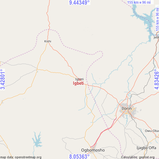
Igbeti GPS coordinates[2]
8° 44' 57.156" North, 4° 7' 52.068" East
| Map corner | latitude | longitude |
|---|---|---|
| Upper-left | 9.44349°, | 3.42801° |
| Center: | 8.74921°, | 4.13113° |
| Lower-right: | 8.05363°, | 4.83426° |
| Map W x H: | 154.5×154.5 km | = 96×96mi |
| max Lat: | 13.7543° ⇑47.4% North |
| Igbeti: | 8.74921° |
| min Lat: | ⇓52.6% South 4.31231° |
| min Long | Igbeti | max Long |
| 2.73333° | 4.13113° | 14.46552° |
| W 9%⇐ | ⇒91% E |
Elevation
Elevation of Igbeti is 371 m = 1217 ft, and this is 74.5 m = 244 ft above average elevation for this country.
| Max E: |
1599 m = 5246 ft | 34.6% |
| Igbeti | 371 m 1217 ft | |
| Avg. | 296.5 m = 973 ft | |
Min E: |
2 m = 7 ft | 65.4% |
See also: Nigeria elevation on elevation.city.
Geographical zone
Igbeti is located in North Torrid zone (between Equator and Tropic of Cancer). Distance of Equator is 972.8 km =604.5 mi to South.| Distance of | km | miles | from Igbeti |
|---|---|---|---|
| North Pole | 9034.2 | 5613.6 | to North |
| Arctic Circle | 6428.4 | 3994.4 | to North |
| Tropic Cancer | 1633.1 | 1014.8 | to North |
| Equator | 972.8 | 604.5 | to South |


Nearby cities:
15 places around Igbeti: (largest is in red/bold)
• Afon
65.2 km =40.5 mi,  138°
138°
• Ago Are
83.3 km =51.8 mi,  250°
250°
• Ago-Amodu
58.5 km =36.4 mi,  256°
256°
• Alapa
31.4 km =19.5 mi,  117°
117°
• Bode Saadu
74.6 km =46.4 mi,  73°
73°
• Fufu
72.9 km =45.3 mi, 117°
• Igboho
42.4 km =26.3 mi,  283°
283°
• Ikoyi-Ile
56.3 km =35 mi,  175°
175°
• Ilorin
53.2 km =33.1 mi, 121°
• Iresa-Adu
79 km =49.1 mi,  158°
158°
• Kisi
48.1 km =29.9 mi,  320°
320°
• Ogbomoso
69.5 km =43.2 mi,  170°
170°
• Oke-Oyi
66.9 km =41.6 mi,  106°
106°
• Saki
81.5 km =50.6 mi, 263°
• Tede
78.3 km =48.7 mi, 254°
Sources, notices
• [Note1] Compared only with cities in Nigeria existing in our database
• [Src1] Map data: © OpenStreetMap contributors (CC-BY-SA)
• [Src2] Other city data from geonames.org with taken over terms of usage.
• [Src3] Geographical zone / Annual Mean Temperature by Robert A. Rohde @ Wikipedia
