Otan Ayegbaju geodata
Otan Ayegbaju (Osun) is a seat of a second-order administrative division; located in Nigeria in Africa/Lagos (GMT+1) time zone. With population of 37,783 people, there are 155 cities with bigger population in this country. Compared to other cities in Nigeria, 53.6% of cities are located further ↑North; 84.2% of cities are located further →East and 81.8% of cities have lower elevation than Otan Ayegbaju. Note1


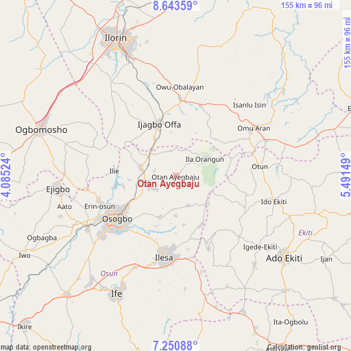
Otan Ayegbaju GPS coordinates[2]
7° 56' 52.188" North, 4° 47' 18.096" East
| Map corner | latitude | longitude |
|---|---|---|
| Upper-left | 8.64359°, | 4.08524° |
| Center: | 7.94783°, | 4.78836° |
| Lower-right: | 7.25088°, | 5.49149° |
| Map W x H: | 154.9×154.9 km | = 96.3×96.3mi |
| max Lat: | 13.7543° ⇑53.6% North |
| Otan Ayegbaju: | 7.94783° |
| min Lat: | ⇓46.4% South 4.31231° |
| min Long | Otan Ayegbaju | max Long |
| 2.73333° | 4.78836° | 14.46552° |
| W 15.8%⇐ | ⇒84.2% E |
Elevation
Elevation of Otan Ayegbaju is 484 m = 1588 ft, and this is 187.5 m = 615 ft above average elevation for this country.
| Max E: |
1599 m = 5246 ft | 18.2% |
| Otan Ayegbaju | 484 m 1588 ft | |
| Avg. | 296.5 m = 973 ft | |
Min E: |
2 m = 7 ft | 81.8% |
See also: Nigeria elevation on elevation.city.
Geographical zone
Otan Ayegbaju is located in North Torrid zone (between Equator and Tropic of Cancer). Distance of Equator is 883.7 km =549.1 mi to South.| Distance of | km | miles | from Otan Ayegbaju |
|---|---|---|---|
| North Pole | 9123.3 | 5669 | to North |
| Arctic Circle | 6517.5 | 4049.8 | to North |
| Tropic Cancer | 1722.2 | 1070.1 | to North |
| Equator | 883.7 | 549.1 | to South |


Nearby cities:
15 places around Otan Ayegbaju: (largest is in red/bold)
• Ajasse Ipo
31.9 km =19.8 mi,  5°
5°
• Ibokun
19 km =11.8 mi,  199°
199°
• Ijebu-Jesa
29.6 km =18.4 mi,  173°
173°
• Ijero-Ekiti
34.1 km =21.2 mi,  115°
115°
• Ikirun
13.9 km =8.6 mi,  253°
253°
• Ila Orangun
14.9 km =9.3 mi,  58°
58°
• Ilemona
22.9 km =14.2 mi,  322°
322°
• Ipoti
32.8 km =20.4 mi,  104°
104°
• Iragbiji
12.2 km =7.6 mi, 246°
• Offa
23.6 km =14.7 mi,  341°
341°
• Oke Ila
21.5 km =13.4 mi,  89°
89°
• Oke Mesi
20.3 km =12.6 mi,  135°
135°
• Okuku
15 km =9.3 mi,  301°
301°
• Osogbo
32.2 km =20 mi,  232°
232°
• Oyan
11.6 km =7.2 mi,  348°
348°
Sources, notices
• [Note1] Compared only with cities in Nigeria existing in our database
• [Src1] Map data: © OpenStreetMap contributors (CC-BY-SA)
• [Src2] Other city data from geonames.org with taken over terms of usage.
• [Src3] Geographical zone / Annual Mean Temperature by Robert A. Rohde @ Wikipedia
