Gella geodata
Gella (Adamawa) is a seat of a second-order administrative division; located in Nigeria in Africa/Lagos (GMT+1) time zone. In our database, there are 451 cities with bigger population. Compared to other cities in Nigeria, 65.2% of cities are located further ↓South; 98.2% of cities are located further ←West and 98% of cities have lower elevation than Gella. Note1


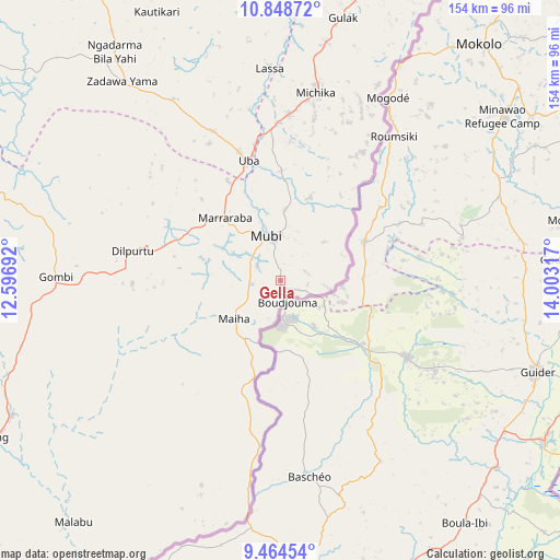
Gella GPS coordinates[2]
10° 9' 26.568" North, 13° 18' 0.144" East
| Map corner | latitude | longitude |
|---|---|---|
| Upper-left | 10.84872°, | 12.59692° |
| Center: | 10.15738°, | 13.30004° |
| Lower-right: | 9.46454°, | 14.00317° |
| Map W x H: | 153.9×153.9 km | = 95.6×95.6mi |
| max Lat: | 13.7543° ⇑34.8% North |
| Gella: | 10.15738° |
| min Lat: | ⇓65.2% South 4.31231° |
| min Long | Gella | max Long |
| 2.73333° | 13.30004° | 14.46552° |
| W 98.2%⇐ | ⇒1.8% E |
Elevation
Elevation of Gella is 812 m = 2664 ft, and this is 515.5 m = 1691 ft above average elevation for this country.
| Max E: |
1599 m = 5246 ft | 2% |
| Gella | 812 m 2664 ft | |
| Avg. | 296.5 m = 973 ft | |
Min E: |
2 m = 7 ft | 98% |
See also: Nigeria elevation on elevation.city.
Geographical zone
Gella is located in North Torrid zone (between Equator and Tropic of Cancer). Distance of Equator is 1129.4 km =701.8 mi to South.| Distance of | km | miles | from Gella |
|---|---|---|---|
| North Pole | 8877.7 | 5516.3 | to North |
| Arctic Circle | 6271.8 | 3897.1 | to North |
| Tropic Cancer | 1476.5 | 917.5 | to North |
| Equator | 1129.4 | 701.8 | to South |


Nearby cities:
15 places around Gella: (largest is in red/bold)
• Askira
69.6 km =43.2 mi,  322°
322°
• Azare
117.7 km =73.1 mi,  290°
290°
• Chibok
93.4 km =58 mi,  327°
327°
• Gombi
61.6 km =38.3 mi,  271°
271°
• Gulak
74.1 km =46 mi,  13°
13°
• Gwoza
111.7 km =69.4 mi,  22°
22°
• Holma
39.4 km =24.5 mi,  223°
223°
• Hong
41.6 km =25.8 mi,  281°
281°
• Madagali
89 km =55.3 mi, 23°
• Maiha
20.1 km =12.5 mi,  207°
207°
• Michika
52.4 km =32.6 mi, 10°
• Mubi
12.9 km =8 mi,  343°
343°
• Shaffa
112.7 km =70 mi, 290°
• Song
82.7 km =51.4 mi,  243°
243°
• Uba
34.2 km =21.3 mi,  345°
345°
Sources, notices
• [Note1] Compared only with cities in Nigeria existing in our database
• [Src1] Map data: © OpenStreetMap contributors (CC-BY-SA)
• [Src2] Other city data from geonames.org with taken over terms of usage.
• [Src3] Geographical zone / Annual Mean Temperature by Robert A. Rohde @ Wikipedia
