Emuoha geodata
Emuoha (Rivers) is a seat of a second-order administrative division; located in Nigeria in Africa/Lagos (GMT+1) time zone. In our database, there are 451 cities with bigger population. Compared to other cities in Nigeria, 95.5% of cities are located further ↑North; 59.4% of cities are located further →East and 93.9% of cities have higher elevation than Emuoha. Note1


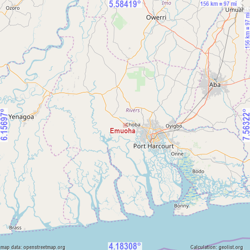
Emuoha GPS coordinates[2]
4° 53' 2.4" North, 6° 51' 36.36" East
| Map corner | latitude | longitude |
|---|---|---|
| Upper-left | 5.58419°, | 6.15697° |
| Center: | 4.884°, | 6.8601° |
| Lower-right: | 4.18308°, | 7.56322° |
| Map W x H: | 155.8×155.8 km | = 96.8×96.8mi |
| max Lat: | 13.7543° ⇑95.5% North |
| Emuoha: | 4.884° |
| min Lat: | ⇓4.5% South 4.31231° |
| min Long | Emuoha | max Long |
| 2.73333° | 6.8601° | 14.46552° |
| W 40.6%⇐ | ⇒59.4% E |
Elevation
Elevation of Emuoha is 15 m = 49 ft, and this is 281.5 m = 924 ft below average elevation for this country.
| Max E: |
1599 m = 5246 ft | 93.9% |
| Avg. | 296.5 m = 973 ft | |
| Emuoha | 15 m = 49 ft | |
Min E: |
2 m = 7 ft | 6.1% |
See also: Nigeria elevation on elevation.city.
Geographical zone
Emuoha is located in North Torrid zone (between Equator and Tropic of Cancer). Distance of Equator is 543 km =337.4 mi to South.| Distance of | km | miles | from Emuoha |
|---|---|---|---|
| North Pole | 9464 | 5880.7 | to North |
| Arctic Circle | 6858.1 | 4261.4 | to North |
| Tropic Cancer | 2062.9 | 1281.8 | to North |
| Equator | 543 | 337.4 | to South |


Nearby cities:
15 places around Emuoha: (largest is in red/bold)
• Abonnema
19.5 km =12.1 mi,  209°
209°
• Abua
24 km =14.9 mi,  262°
262°
• Ahoada
32.1 km =19.9 mi,  313°
313°
• Buguma
16.4 km =10.2 mi,  179°
179°
• Degema
18.3 km =11.4 mi, 214°
• Degema Hulk
18.3 km =11.4 mi,  221°
221°
• Elele
24.6 km =15.3 mi,  348°
348°
• Isiokpo
13.2 km =8.2 mi,  6°
6°
• Nchia
30.6 km =19 mi,  109°
109°
• Obonoma
20.7 km =12.9 mi,  201°
201°
• Ogu
41.6 km =25.8 mi,  115°
115°
• Okehi
41.9 km =26 mi,  47°
47°
• Okrika
29.4 km =18.3 mi, 122°
• Port Harcourt
20.7 km =12.9 mi, 124°
• Rumuodomaya
15.8 km =9.8 mi,  86°
86°
Sources, notices
• [Note1] Compared only with cities in Nigeria existing in our database
• [Src1] Map data: © OpenStreetMap contributors (CC-BY-SA)
• [Src2] Other city data from geonames.org with taken over terms of usage.
• [Src3] Geographical zone / Annual Mean Temperature by Robert A. Rohde @ Wikipedia
