Buguma geodata
Buguma (Rivers) is a seat of a second-order administrative division; located in Nigeria in Africa/Lagos (GMT+1) time zone. With population of 135,404 people, there are 62 cities with bigger population in this country. Compared to other cities in Nigeria, 97.8% of cities are located further ↑North; 59.2% of cities are located further →East and 98.5% of cities have higher elevation than Buguma. Note1


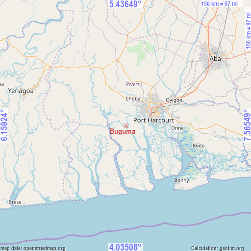
Buguma GPS coordinates[2]
4° 44' 10.104" North, 6° 51' 44.496" East
| Map corner | latitude | longitude |
|---|---|---|
| Upper-left | 5.43649°, | 6.15924° |
| Center: | 4.73614°, | 6.86236° |
| Lower-right: | 4.03508°, | 7.56549° |
| Map W x H: | 155.8×155.8 km | = 96.8×96.8mi |
| max Lat: | 13.7543° ⇑97.8% North |
| Buguma: | 4.73614° |
| min Lat: | ⇓2.2% South 4.31231° |
| min Long | Buguma | max Long |
| 2.73333° | 6.86236° | 14.46552° |
| W 40.8%⇐ | ⇒59.2% E |
Elevation
Elevation of Buguma is 7 m = 23 ft, and this is 289.5 m = 950 ft below average elevation for this country.
| Max E: |
1599 m = 5246 ft | 98.5% |
| Avg. | 296.5 m = 973 ft | |
| Buguma | 7 m = 23 ft | |
Min E: |
2 m = 7 ft | 1.5% |
See also: Buguma elevation on elevation.city.
Geographical zone
Buguma is located in North Torrid zone (between Equator and Tropic of Cancer). Distance of Equator is 526.6 km =327.2 mi to South.| Distance of | km | miles | from Buguma |
|---|---|---|---|
| North Pole | 9480.5 | 5890.9 | to North |
| Arctic Circle | 6874.6 | 4271.7 | to North |
| Tropic Cancer | 2079.3 | 1292 | to North |
| Equator | 526.6 | 327.2 | to South |


Nearby cities:
15 places around Buguma: (largest is in red/bold)
• Abonnema
10 km =6.2 mi,  267°
267°
• Abua
27.6 km =17.1 mi,  299°
299°
• Ahoada
45.2 km =28.1 mi,  328°
328°
• Degema
10.7 km =6.6 mi,  277°
277°
• Degema Hulk
12.8 km =8 mi, 282°
• Elele
40.9 km =25.4 mi,  352°
352°
• Emuoha
16.4 km =10.2 mi,  359°
359°
• Isiokpo
29.6 km =18.4 mi,  2°
2°
• Nchia
29.3 km =18.2 mi,  77°
77°
• Obonoma
8.4 km =5.2 mi,  250°
250°
• Ogu
37.3 km =23.2 mi,  92°
92°
• Okrika
24.5 km =15.2 mi, 88°
• Port Harcourt
17.4 km =10.8 mi,  74°
74°
• Rumuodomaya
23.4 km =14.5 mi,  41°
41°
• Saakpenwa
44.4 km =27.6 mi, 92°
Sources, notices
• [Note1] Compared only with cities in Nigeria existing in our database
• [Src1] Map data: © OpenStreetMap contributors (CC-BY-SA)
• [Src2] Other city data from geonames.org with taken over terms of usage.
• [Src3] Geographical zone / Annual Mean Temperature by Robert A. Rohde @ Wikipedia
