Abonnema geodata
Abonnema (Rivers) is a seat of a second-order administrative division; located in Nigeria in Africa/Lagos (GMT+1) time zone. In our database, there are 451 cities with bigger population. Compared to other cities in Nigeria, 98% of cities are located further ↑North; 61.2% of cities are located further →East and 99.1% of cities have higher elevation than Abonnema. Note1


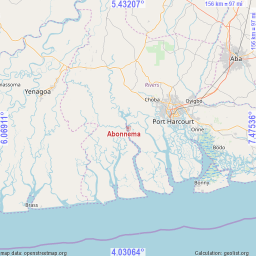
Abonnema GPS coordinates[2]
4° 43' 54.156" North, 6° 46' 20.028" East
| Map corner | latitude | longitude |
|---|---|---|
| Upper-left | 5.43207°, | 6.06911° |
| Center: | 4.73171°, | 6.77223° |
| Lower-right: | 4.03064°, | 7.47536° |
| Map W x H: | 155.8×155.8 km | = 96.8×96.8mi |
| max Lat: | 13.7543° ⇑98% North |
| Abonnema: | 4.73171° |
| min Lat: | ⇓2% South 4.31231° |
| min Long | Abonnema | max Long |
| 2.73333° | 6.77223° | 14.46552° |
| W 38.8%⇐ | ⇒61.2% E |
Elevation
Elevation of Abonnema is 6 m = 20 ft, and this is 290.5 m = 953 ft below average elevation for this country.
| Max E: |
1599 m = 5246 ft | 99.1% |
| Avg. | 296.5 m = 973 ft | |
| Abonnema | 6 m = 20 ft | |
Min E: |
2 m = 7 ft | 0.9% |
See also: Nigeria elevation on elevation.city.
Geographical zone
Abonnema is located in North Torrid zone (between Equator and Tropic of Cancer). Distance of Equator is 526.1 km =326.9 mi to South.| Distance of | km | miles | from Abonnema |
|---|---|---|---|
| North Pole | 9480.9 | 5891.2 | to North |
| Arctic Circle | 6875.1 | 4272 | to North |
| Tropic Cancer | 2079.8 | 1292.3 | to North |
| Equator | 526.1 | 326.9 | to South |


Nearby cities:
15 places around Abonnema: (largest is in red/bold)
• Abua
19.9 km =12.4 mi,  314°
314°
• Ahoada
41.3 km =25.7 mi,  340°
340°
• Buguma
10 km =6.2 mi,  87°
87°
• Degema
1.9 km =1.2 mi, 339°
• Degema Hulk
4.2 km =2.6 mi,  322°
322°
• Elele
41.3 km =25.7 mi,  6°
6°
• Emuoha
19.5 km =12.1 mi,  29°
29°
• Isiokpo
32.1 km =19.9 mi,  20°
20°
• Nchia
39.2 km =24.4 mi,  79°
79°
• Nembe
46.3 km =28.8 mi,  242°
242°
• Obonoma
3.1 km =1.9 mi,  137°
137°
• Ogu
47.3 km =29.4 mi, 91°
• Okrika
34.5 km =21.4 mi, 88°
• Port Harcourt
27.2 km =16.9 mi, 79°
• Rumuodomaya
31.2 km =19.4 mi,  54°
54°
Sources, notices
• [Note1] Compared only with cities in Nigeria existing in our database
• [Src1] Map data: © OpenStreetMap contributors (CC-BY-SA)
• [Src2] Other city data from geonames.org with taken over terms of usage.
• [Src3] Geographical zone / Annual Mean Temperature by Robert A. Rohde @ Wikipedia
