Dengi geodata
Dengi (Plateau) is a seat of a second-order administrative division; located in Nigeria in Africa/Lagos (GMT+1) time zone. With population of 6,276 people, there are 434 cities with bigger population in this country. Compared to other cities in Nigeria, 58.5% of cities are located further ↓South; 84.3% of cities are located further ←West and 67.8% of cities have lower elevation than Dengi. Note1


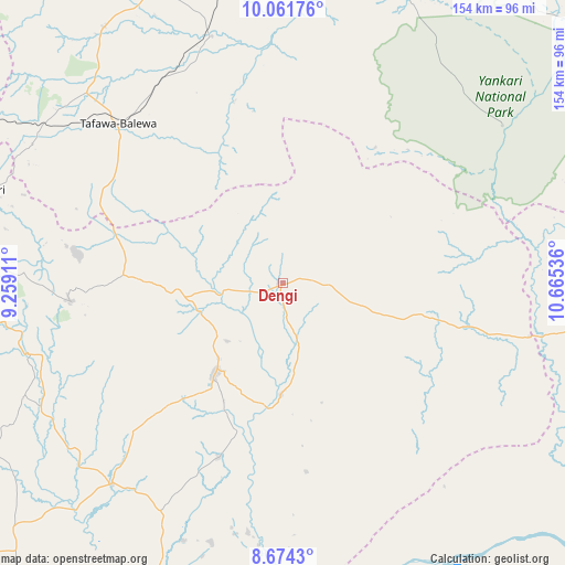
Dengi GPS coordinates[2]
9° 22' 7.392" North, 9° 57' 44.028" East
| Map corner | latitude | longitude |
|---|---|---|
| Upper-left | 10.06176°, | 9.25911° |
| Center: | 9.36872°, | 9.96223° |
| Lower-right: | 8.6743°, | 10.66536° |
| Map W x H: | 154.3×154.3 km | = 95.9×95.9mi |
| max Lat: | 13.7543° ⇑41.5% North |
| Dengi: | 9.36872° |
| min Lat: | ⇓58.5% South 4.31231° |
| min Long | Dengi | max Long |
| 2.73333° | 9.96223° | 14.46552° |
| W 84.3%⇐ | ⇒15.7% E |
Elevation
Elevation of Dengi is 384 m = 1260 ft, and this is 87.5 m = 287 ft above average elevation for this country.
| Max E: |
1599 m = 5246 ft | 32.2% |
| Dengi | 384 m 1260 ft | |
| Avg. | 296.5 m = 973 ft | |
Min E: |
2 m = 7 ft | 67.8% |
See also: Nigeria elevation on elevation.city.
Geographical zone
Dengi is located in North Torrid zone (between Equator and Tropic of Cancer). Distance of Equator is 1041.7 km =647.3 mi to South.| Distance of | km | miles | from Dengi |
|---|---|---|---|
| North Pole | 8965.4 | 5570.8 | to North |
| Arctic Circle | 6359.5 | 3951.6 | to North |
| Tropic Cancer | 1564.2 | 971.9 | to North |
| Equator | 1041.7 | 647.3 | to South |


Nearby cities:
15 places around Dengi: (largest is in red/bold)
• Amper
28.7 km =17.8 mi,  266°
266°
• Bogoro
51.5 km =32 mi,  310°
310°
• Boi
54.9 km =34.1 mi,  292°
292°
• Bununu
64.9 km =40.3 mi,  331°
331°
• Kwal
37.6 km =23.4 mi, 270°
• Langtang
31.5 km =19.6 mi,  216°
216°
• Lere
78.1 km =48.5 mi,  299°
299°
• Mabudi
73.6 km =45.7 mi,  195°
195°
• Pankshin
58 km =36 mi, 265°
• Shendam
71.9 km =44.7 mi, 220°
• Tafawa Balewa
62.6 km =38.9 mi, 314°
• Tunkus
54.3 km =33.7 mi, 224°
• Wase
30.5 km =19 mi,  181°
181°
• Yelwa
69.6 km =43.2 mi,  211°
211°
• Yuli
50 km =31.1 mi,  43°
43°
Sources, notices
• [Note1] Compared only with cities in Nigeria existing in our database
• [Src1] Map data: © OpenStreetMap contributors (CC-BY-SA)
• [Src2] Other city data from geonames.org with taken over terms of usage.
• [Src3] Geographical zone / Annual Mean Temperature by Robert A. Rohde @ Wikipedia
