Shendam geodata
Shendam (Plateau) is a seat of a second-order administrative division; located in Nigeria in Africa/Lagos (GMT+1) time zone. In our database, there are 451 cities with bigger population. Compared to other cities in Nigeria, 53.6% of cities are located further ↓South; 80.6% of cities are located further ←West and 60.9% of cities have higher elevation than Shendam. Note1


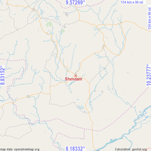
Shendam GPS coordinates[2]
8° 52' 43.176" North, 9° 32' 4.704" East
| Map corner | latitude | longitude |
|---|---|---|
| Upper-left | 9.57269°, | 8.83152° |
| Center: | 8.87866°, | 9.53464° |
| Lower-right: | 8.18332°, | 10.23777° |
| Map W x H: | 154.5×154.5 km | = 96×96mi |
| max Lat: | 13.7543° ⇑46.4% North |
| Shendam: | 8.87866° |
| min Lat: | ⇓53.6% South 4.31231° |
| min Long | Shendam | max Long |
| 2.73333° | 9.53464° | 14.46552° |
| W 80.6%⇐ | ⇒19.4% E |
Elevation
Elevation of Shendam is 201 m = 659 ft, and this is 95.5 m = 313 ft below average elevation for this country.
| Max E: |
1599 m = 5246 ft | 60.9% |
| Avg. | 296.5 m = 973 ft | |
| Shendam | 201 m = 659 ft | |
Min E: |
2 m = 7 ft | 39.1% |
See also: Nigeria elevation on elevation.city.
Geographical zone
Shendam is located in North Torrid zone (between Equator and Tropic of Cancer). Distance of Equator is 987.2 km =613.4 mi to South.| Distance of | km | miles | from Shendam |
|---|---|---|---|
| North Pole | 9019.8 | 5604.6 | to North |
| Arctic Circle | 6414 | 3985.5 | to North |
| Tropic Cancer | 1618.7 | 1005.8 | to North |
| Equator | 987.2 | 613.4 | to South |


Nearby cities:
15 places around Shendam: (largest is in red/bold)
• Amper
56 km =34.8 mi,  19°
19°
• Baap
33 km =20.5 mi,  282°
282°
• Boi
76 km =47.2 mi,  357°
357°
• Bokkos
75.5 km =46.9 mi,  308°
308°
• Dengi
71.9 km =44.7 mi,  40°
40°
• Ibi
80.9 km =50.3 mi,  163°
163°
• Kwal
55.6 km =34.5 mi,  9°
9°
• Kwolla
26.9 km =16.7 mi, 275°
• Langtang
40.6 km =25.2 mi, 43°
• Mabudi
32.1 km =19.9 mi,  120°
120°
• Pankshin
50.9 km =31.6 mi,  347°
347°
• Panyam
68.5 km =42.6 mi,  329°
329°
• Tunkus
18.1 km =11.2 mi,  28°
28°
• Wase
52.1 km =32.4 mi,  62°
62°
• Yelwa
12 km =7.5 mi,  114°
114°
Sources, notices
• [Note1] Compared only with cities in Nigeria existing in our database
• [Src1] Map data: © OpenStreetMap contributors (CC-BY-SA)
• [Src2] Other city data from geonames.org with taken over terms of usage.
• [Src3] Geographical zone / Annual Mean Temperature by Robert A. Rohde @ Wikipedia
