Yelwa geodata
Yelwa (Plateau) is a populated place; located in Nigeria in Africa/Lagos (GMT+1) time zone. With population of 13,234 people, there are 269 cities with bigger population in this country. Compared to other cities in Nigeria, 53% of cities are located further ↓South; 81.7% of cities are located further ←West and 58.5% of cities have higher elevation than Yelwa. Note1


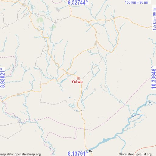
Yelwa GPS coordinates[2]
8° 49' 59.988" North, 9° 37' 59.988" East
| Map corner | latitude | longitude |
|---|---|---|
| Upper-left | 9.52744°, | 8.93021° |
| Center: | 8.83333°, | 9.63333° |
| Lower-right: | 8.13791°, | 10.33646° |
| Map W x H: | 154.5×154.5 km | = 96×96mi |
| max Lat: | 13.7543° ⇑47% North |
| Yelwa: | 8.83333° |
| min Lat: | ⇓53% South 4.31231° |
| min Long | Yelwa | max Long |
| 2.73333° | 9.63333° | 14.46552° |
| W 81.7%⇐ | ⇒18.3% E |
Elevation
Elevation of Yelwa is 221 m = 725 ft, and this is 75.5 m = 248 ft below average elevation for this country.
| Max E: |
1599 m = 5246 ft | 58.5% |
| Avg. | 296.5 m = 973 ft | |
| Yelwa | 221 m = 725 ft | |
Min E: |
2 m = 7 ft | 41.5% |
See also: Nigeria elevation on elevation.city.
Geographical zone
Yelwa is located in North Torrid zone (between Equator and Tropic of Cancer). Distance of Equator is 982.2 km =610.3 mi to South.| Distance of | km | miles | from Yelwa |
|---|---|---|---|
| North Pole | 9024.9 | 5607.8 | to North |
| Arctic Circle | 6419 | 3988.6 | to North |
| Tropic Cancer | 1623.7 | 1008.9 | to North |
| Equator | 982.2 | 610.3 | to South |


Nearby cities:
15 places around Yelwa: (largest is in red/bold)
• Amper
58.5 km =36.4 mi,  7°
7°
• Baap
44.8 km =27.8 mi,  285°
285°
• Boi
82.2 km =51.1 mi,  349°
349°
• Bokkos
87.2 km =54.2 mi,  306°
306°
• Dengi
69.6 km =43.2 mi,  31°
31°
• Ibi
73.5 km =45.7 mi,  170°
170°
• Kwal
59.8 km =37.2 mi,  358°
358°
• Kwolla
38.4 km =23.9 mi,  281°
281°
• Langtang
38.4 km =23.9 mi, 26°
• Mabudi
20.2 km =12.6 mi,  124°
124°
• Pankshin
58.9 km =36.6 mi,  338°
338°
• Panyam
78.7 km =48.9 mi,  324°
324°
• Shendam
12 km =7.5 mi, 294°
• Tunkus
21.1 km =13.1 mi, 354°
• Wase
45.8 km =28.5 mi,  50°
50°
Sources, notices
• [Note1] Compared only with cities in Nigeria existing in our database
• [Src1] Map data: © OpenStreetMap contributors (CC-BY-SA)
• [Src2] Other city data from geonames.org with taken over terms of usage.
• [Src3] Geographical zone / Annual Mean Temperature by Robert A. Rohde @ Wikipedia
