Dankalwa geodata
Dankalwa (Yobe) is a populated place; located in Nigeria in Africa/Lagos (GMT+1) time zone. With population of 5,730 people, there are 450 cities with bigger population in this country. Compared to other cities in Nigeria, 81% of cities are located further ↓South; 94.9% of cities are located further ←West and 69.6% of cities have lower elevation than Dankalwa. Note1


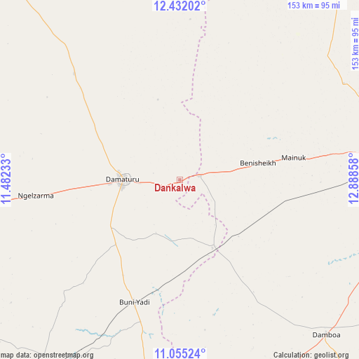
Dankalwa GPS coordinates[2]
11° 44' 40.164" North, 12° 11' 7.62" East
| Map corner | latitude | longitude |
|---|---|---|
| Upper-left | 12.43202°, | 11.48233° |
| Center: | 11.74449°, | 12.18545° |
| Lower-right: | 11.05524°, | 12.88858° |
| Map W x H: | 153.1×153.1 km | = 95.1×95.1mi |
| max Lat: | 13.7543° ⇑19% North |
| Dankalwa: | 11.74449° |
| min Lat: | ⇓81% South 4.31231° |
| min Long | Dankalwa | max Long |
| 2.73333° | 12.18545° | 14.46552° |
| W 94.9%⇐ | ⇒5.1% E |
Elevation
Elevation of Dankalwa is 397 m = 1302 ft, and this is 100.5 m = 330 ft above average elevation for this country.
| Max E: |
1599 m = 5246 ft | 30.4% |
| Dankalwa | 397 m 1302 ft | |
| Avg. | 296.5 m = 973 ft | |
Min E: |
2 m = 7 ft | 69.6% |
See also: Nigeria elevation on elevation.city.
Geographical zone
Dankalwa is located in North Torrid zone (between Equator and Tropic of Cancer). Distance of this Northern Tropic circle is 1300.1 km =807.8 mi to North.| Distance of | km | miles | from Dankalwa |
|---|---|---|---|
| North Pole | 8701.2 | 5406.7 | to North |
| Arctic Circle | 6095.3 | 3787.4 | to North |
| Tropic Cancer | 1300.1 | 807.8 | to North |
| Equator | 1305.9 | 811.4 | to South |


Nearby cities:
15 places around Dankalwa: (largest is in red/bold)
• Babban Gida
64.1 km =39.8 mi,  315°
315°
• Bara
105.3 km =65.4 mi,  211°
211°
• Benisheikh
34.1 km =21.2 mi,  77°
77°
• Bornu Yassu
72.2 km =44.9 mi,  35°
35°
• Buni Yadi
55.7 km =34.6 mi,  200°
200°
• Damagum
92.9 km =57.7 mi,  265°
265°
• Damaturu
24.5 km =15.2 mi, 270°
• Damboa
90.3 km =56.1 mi,  136°
136°
• Daura
87.5 km =54.4 mi,  255°
255°
• Goniri
32.1 km =19.9 mi,  154°
154°
• Gubio
105.8 km =65.7 mi, 37°
• Gujba
38.6 km =24 mi,  225°
225°
• Lajere
85.2 km =52.9 mi,  287°
287°
• Magumeri
80.9 km =50.3 mi,  59°
59°
• Yajiwa
70.5 km =43.8 mi,  124°
124°
Sources, notices
• [Note1] Compared only with cities in Nigeria existing in our database
• [Src1] Map data: © OpenStreetMap contributors (CC-BY-SA)
• [Src2] Other city data from geonames.org with taken over terms of usage.
• [Src3] Geographical zone / Annual Mean Temperature by Robert A. Rohde @ Wikipedia
