Mutum Biyu geodata
Mutum Biyu (Taraba) is a seat of a second-order administrative division; located in Nigeria in Africa/Lagos (GMT+1) time zone. With population of 11,702 people, there are 302 cities with bigger population in this country. Compared to other cities in Nigeria, 51.9% of cities are located further ↓South; 88.4% of cities are located further ←West and 70.3% of cities have higher elevation than Mutum Biyu. Note1


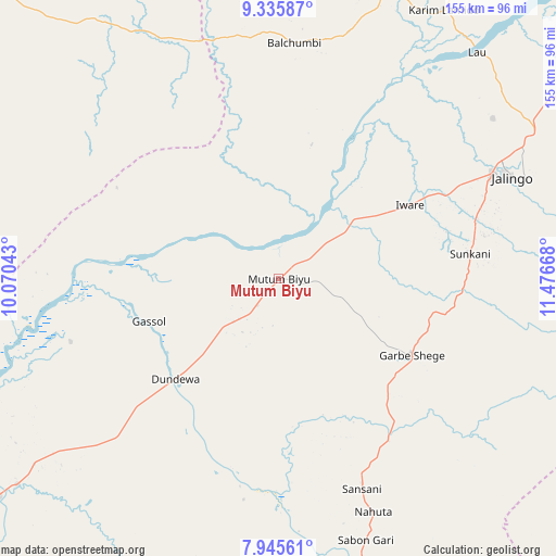
Mutum Biyu GPS coordinates[2]
8° 38' 28.968" North, 10° 46' 24.78" East
| Map corner | latitude | longitude |
|---|---|---|
| Upper-left | 9.33587°, | 10.07043° |
| Center: | 8.64138°, | 10.77355° |
| Lower-right: | 7.94561°, | 11.47668° |
| Map W x H: | 154.6×154.6 km | = 96.1×96.1mi |
| max Lat: | 13.7543° ⇑48.1% North |
| Mutum Biyu: | 8.64138° |
| min Lat: | ⇓51.9% South 4.31231° |
| min Long | Mutum Biyu | max Long |
| 2.73333° | 10.77355° | 14.46552° |
| W 88.4%⇐ | ⇒11.6% E |
Elevation
Elevation of Mutum Biyu is 146 m = 479 ft, and this is 150.5 m = 494 ft below average elevation for this country.
| Max E: |
1599 m = 5246 ft | 70.3% |
| Avg. | 296.5 m = 973 ft | |
| Mutum Biyu | 146 m = 479 ft | |
Min E: |
2 m = 7 ft | 29.7% |
See also: Nigeria elevation on elevation.city.
Geographical zone
Mutum Biyu is located in North Torrid zone (between Equator and Tropic of Cancer). Distance of Equator is 960.8 km =597 mi to South.| Distance of | km | miles | from Mutum Biyu |
|---|---|---|---|
| North Pole | 9046.2 | 5621 | to North |
| Arctic Circle | 6440.3 | 4001.8 | to North |
| Tropic Cancer | 1645.1 | 1022.2 | to North |
| Equator | 960.8 | 597 | to South |


Nearby cities:
15 places around Mutum Biyu: (largest is in red/bold)
• Beli
89.7 km =55.7 mi,  165°
165°
• Dengi
120.3 km =74.8 mi,  312°
312°
• Gassol
37.9 km =23.5 mi,  251°
251°
• Ibi
124.2 km =77.2 mi, 245°
• Jalingo
70.2 km =43.6 mi,  66°
66°
• Karim Lamido
87.5 km =54.4 mi,  31°
31°
• Langtang
121.4 km =75.4 mi,  297°
297°
• Lau
83.7 km =52 mi,  41°
41°
• Mabudi
109.1 km =67.8 mi,  275°
275°
• Pantisawa
87.9 km =54.6 mi, 67°
• Sunkani
53.6 km =33.3 mi,  82°
82°
• Wase
103 km =64 mi, 299°
• Yelwa
127.1 km =79 mi, 279°
• Yuli
129.6 km =80.5 mi,  334°
334°
• Zing
113.9 km =70.8 mi, 70°
Sources, notices
• [Note1] Compared only with cities in Nigeria existing in our database
• [Src1] Map data: © OpenStreetMap contributors (CC-BY-SA)
• [Src2] Other city data from geonames.org with taken over terms of usage.
• [Src3] Geographical zone / Annual Mean Temperature by Robert A. Rohde @ Wikipedia
