Agenebode geodata
Agenebode (Edo) is a seat of a second-order administrative division; located in Nigeria in Africa/Lagos (GMT+1) time zone. With population of 12,730 people, there are 279 cities with bigger population in this country. Compared to other cities in Nigeria, 67.4% of cities are located further ↑North; 62.4% of cities are located further →East and 85.4% of cities have higher elevation than Agenebode. Note1


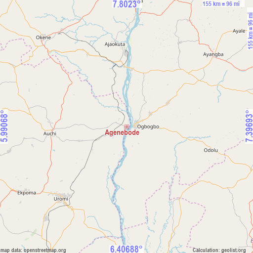
Agenebode GPS coordinates[2]
7° 6' 18.432" North, 6° 41' 37.716" East
| Map corner | latitude | longitude |
|---|---|---|
| Upper-left | 7.8023°, | 5.99068° |
| Center: | 7.10512°, | 6.69381° |
| Lower-right: | 6.40688°, | 7.39693° |
| Map W x H: | 155.2×155.2 km | = 96.4×96.4mi |
| max Lat: | 13.7543° ⇑67.4% North |
| Agenebode: | 7.10512° |
| min Lat: | ⇓32.6% South 4.31231° |
| min Long | Agenebode | max Long |
| 2.73333° | 6.69381° | 14.46552° |
| W 37.6%⇐ | ⇒62.4% E |
Elevation
Elevation of Agenebode is 55 m = 180 ft, and this is 241.5 m = 792 ft below average elevation for this country.
| Max E: |
1599 m = 5246 ft | 85.4% |
| Avg. | 296.5 m = 973 ft | |
| Agenebode | 55 m = 180 ft | |
Min E: |
2 m = 7 ft | 14.6% |
See also: Nigeria elevation on elevation.city.
Geographical zone
Agenebode is located in North Torrid zone (between Equator and Tropic of Cancer). Distance of Equator is 790 km =490.9 mi to South.| Distance of | km | miles | from Agenebode |
|---|---|---|---|
| North Pole | 9217 | 5727.2 | to North |
| Arctic Circle | 6611.2 | 4108 | to North |
| Tropic Cancer | 1815.9 | 1128.3 | to North |
| Equator | 790 | 490.9 | to South |


Nearby cities:
15 places around Agenebode: (largest is in red/bold)
• Abocho
60.7 km =37.7 mi,  32°
32°
• Adani
53.6 km =33.3 mi,  139°
139°
• Adogo
50.8 km =31.6 mi,  332°
332°
• Adoru
53.7 km =33.4 mi,  105°
105°
• Ajaka
16.4 km =10.2 mi,  62°
62°
• Ajaokuta
51 km =31.7 mi,  355°
355°
• Auchi
47.7 km =29.6 mi,  264°
264°
• Fugar
21.6 km =13.4 mi,  265°
265°
• Idah
5 km =3.1 mi,  79°
79°
• Illushi
48.9 km =30.4 mi,  188°
188°
• Ogurugu
45.4 km =28.2 mi, 141°
• Onyedega
24.9 km =15.5 mi,  184°
184°
• Ubiaja
60.5 km =37.6 mi,  214°
214°
• Ugwolawo
29.2 km =18.1 mi, 59°
• Uromi
60.1 km =37.3 mi,  221°
221°
Sources, notices
• [Note1] Compared only with cities in Nigeria existing in our database
• [Src1] Map data: © OpenStreetMap contributors (CC-BY-SA)
• [Src2] Other city data from geonames.org with taken over terms of usage.
• [Src3] Geographical zone / Annual Mean Temperature by Robert A. Rohde @ Wikipedia
