Idah geodata
Idah (Kogi) is a seat of a second-order administrative division; located in Nigeria in Africa/Lagos (GMT+1) time zone. With population of 68,703 people, there are 137 cities with bigger population in this country. Compared to other cities in Nigeria, 67.2% of cities are located further ↑North; 62% of cities are located further →East and 81.8% of cities have higher elevation than Idah. Note1


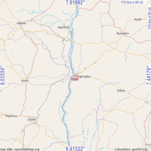
Idah GPS coordinates[2]
7° 6' 48.42" North, 6° 44' 19.176" East
| Map corner | latitude | longitude |
|---|---|---|
| Upper-left | 7.81062°, | 6.03554° |
| Center: | 7.11345°, | 6.73866° |
| Lower-right: | 6.41522°, | 7.44179° |
| Map W x H: | 155.2×155.2 km | = 96.4×96.4mi |
| max Lat: | 13.7543° ⇑67.2% North |
| Idah: | 7.11345° |
| min Lat: | ⇓32.8% South 4.31231° |
| min Long | Idah | max Long |
| 2.73333° | 6.73866° | 14.46552° |
| W 38%⇐ | ⇒62% E |
Elevation
Elevation of Idah is 73 m = 240 ft, and this is 223.5 m = 733 ft below average elevation for this country.
| Max E: |
1599 m = 5246 ft | 81.8% |
| Avg. | 296.5 m = 973 ft | |
| Idah | 73 m = 240 ft | |
Min E: |
2 m = 7 ft | 18.2% |
See also: Idah elevation on elevation.city.
Geographical zone
Idah is located in North Torrid zone (between Equator and Tropic of Cancer). Distance of Equator is 790.9 km =491.4 mi to South.| Distance of | km | miles | from Idah |
|---|---|---|---|
| North Pole | 9216.1 | 5726.6 | to North |
| Arctic Circle | 6610.2 | 4107.4 | to North |
| Tropic Cancer | 1815 | 1127.8 | to North |
| Equator | 790.9 | 491.4 | to South |


Nearby cities:
15 places around Idah: (largest is in red/bold)
• Abocho
57.4 km =35.7 mi,  28°
28°
• Adani
51.3 km =31.9 mi,  144°
144°
• Adogo
52.5 km =32.6 mi,  327°
327°
• Adoru
49.2 km =30.6 mi,  107°
107°
• Agenebode
5 km =3.1 mi,  259°
259°
• Ajaka
11.7 km =7.3 mi,  54°
54°
• Ajaokuta
50.8 km =31.6 mi,  349°
349°
• Auchi
52.7 km =32.7 mi, 264°
• Fugar
26.6 km =16.5 mi, 264°
• Illushi
50.7 km =31.5 mi,  193°
193°
• Ogurugu
43.2 km =26.8 mi,  147°
147°
• Onyedega
26.6 km =16.5 mi,  195°
195°
• Ubiaja
64.1 km =39.8 mi,  217°
217°
• Ugwolawo
24.5 km =15.2 mi,  56°
56°
• Uromi
64.1 km =39.8 mi, 224°
Sources, notices
• [Note1] Compared only with cities in Nigeria existing in our database
• [Src1] Map data: © OpenStreetMap contributors (CC-BY-SA)
• [Src2] Other city data from geonames.org with taken over terms of usage.
• [Src3] Geographical zone / Annual Mean Temperature by Robert A. Rohde @ Wikipedia
