Nto Edino geodata
Nto Edino (Akwa Ibom) is a seat of a second-order administrative division; located in Nigeria in Africa/Lagos (GMT+1) time zone. In our database, there are 451 cities with bigger population. Compared to other cities in Nigeria, 91.7% of cities are located further ↑North; 55.1% of cities are located further ←West and 81.1% of cities have higher elevation than Nto Edino. Note1


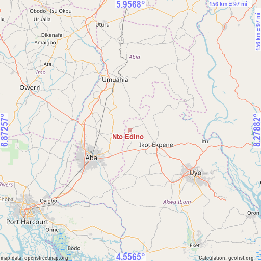
Nto Edino GPS coordinates[2]
5° 15' 25.344" North, 7° 34' 32.484" East
| Map corner | latitude | longitude |
|---|---|---|
| Upper-left | 5.9568°, | 6.87257° |
| Center: | 5.25704°, | 7.57569° |
| Lower-right: | 4.5565°, | 8.27882° |
| Map W x H: | 155.7×155.7 km | = 96.7×96.7mi |
| max Lat: | 13.7543° ⇑91.7% North |
| Nto Edino: | 5.25704° |
| min Lat: | ⇓8.3% South 4.31231° |
| min Long | Nto Edino | max Long |
| 2.73333° | 7.57569° | 14.46552° |
| W 55.1%⇐ | ⇒44.9% E |
Elevation
Elevation of Nto Edino is 75 m = 246 ft, and this is 221.5 m = 727 ft below average elevation for this country.
| Max E: |
1599 m = 5246 ft | 81.1% |
| Avg. | 296.5 m = 973 ft | |
| Nto Edino | 75 m = 246 ft | |
Min E: |
2 m = 7 ft | 18.9% |
See also: Nigeria elevation on elevation.city.
Geographical zone
Nto Edino is located in North Torrid zone (between Equator and Tropic of Cancer). Distance of Equator is 584.5 km =363.2 mi to South.| Distance of | km | miles | from Nto Edino |
|---|---|---|---|
| North Pole | 9422.5 | 5854.9 | to North |
| Arctic Circle | 6816.6 | 4235.6 | to North |
| Tropic Cancer | 2021.4 | 1256 | to North |
| Equator | 584.5 | 363.2 | to South |


Nearby cities:
15 places around Nto Edino: (largest is in red/bold)
• Aba
28.6 km =17.8 mi,  234°
234°
• Afaha Ikot Ebak
17.2 km =10.7 mi,  148°
148°
• Bende
34.2 km =21.3 mi,  10°
10°
• Ibiaku Ntok Okpo
16 km =9.9 mi,  69°
69°
• Ikot Ekpene
17.5 km =10.9 mi,  118°
118°
• Isiala Oboro
16.6 km =10.3 mi,  357°
357°
• Itu
35.6 km =22.1 mi,  310°
310°
• Odoro Ikpe
22.5 km =14 mi,  59°
59°
• Oko Ita
36.1 km =22.4 mi,  101°
101°
• Okpuala-Ngwa
23.6 km =14.7 mi,  298°
298°
• Omoba
18.8 km =11.7 mi,  265°
265°
• Osisioma
30.1 km =18.7 mi,  248°
248°
• Umuahia
31.1 km =19.3 mi,  343°
343°
• Urua Inyang
26.3 km =16.3 mi,  188°
188°
• Utu Etim Ekpo
28.3 km =17.6 mi,  172°
172°
Sources, notices
• [Note1] Compared only with cities in Nigeria existing in our database
• [Src1] Map data: © OpenStreetMap contributors (CC-BY-SA)
• [Src2] Other city data from geonames.org with taken over terms of usage.
• [Src3] Geographical zone / Annual Mean Temperature by Robert A. Rohde @ Wikipedia
