Isiala Oboro geodata
Isiala Oboro (Abia) is a seat of a second-order administrative division; located in Nigeria in Africa/Lagos (GMT+1) time zone. In our database, there are 451 cities with bigger population. Compared to other cities in Nigeria, 90.7% of cities are located further ↑North; 54.9% of cities are located further ←West and 71% of cities have higher elevation than Isiala Oboro. Note1


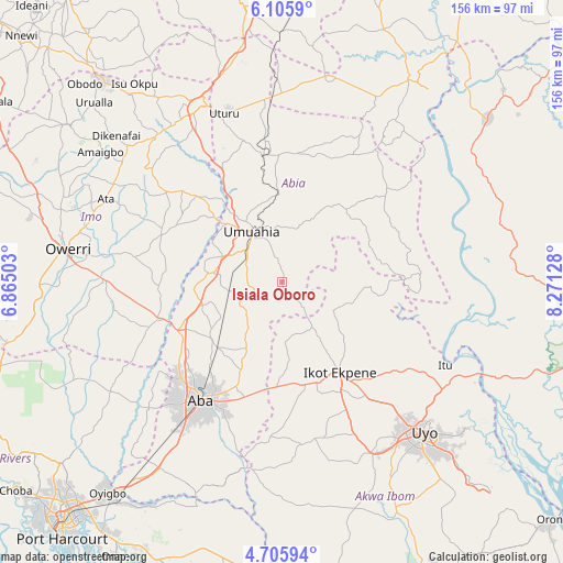
Isiala Oboro GPS coordinates[2]
5° 24' 22.752" North, 7° 34' 5.376" East
| Map corner | latitude | longitude |
|---|---|---|
| Upper-left | 6.1059°, | 6.86503° |
| Center: | 5.40632°, | 7.56816° |
| Lower-right: | 4.70594°, | 8.27128° |
| Map W x H: | 155.7×155.7 km | = 96.7×96.7mi |
| max Lat: | 13.7543° ⇑90.7% North |
| Isiala Oboro: | 5.40632° |
| min Lat: | ⇓9.3% South 4.31231° |
| min Long | Isiala Oboro | max Long |
| 2.73333° | 7.56816° | 14.46552° |
| W 54.9%⇐ | ⇒45.1% E |
Elevation
Elevation of Isiala Oboro is 141 m = 463 ft, and this is 155.5 m = 510 ft below average elevation for this country.
| Max E: |
1599 m = 5246 ft | 71% |
| Avg. | 296.5 m = 973 ft | |
| Isiala Oboro | 141 m = 463 ft | |
Min E: |
2 m = 7 ft | 29% |
See also: Nigeria elevation on elevation.city.
Geographical zone
Isiala Oboro is located in North Torrid zone (between Equator and Tropic of Cancer). Distance of Equator is 601.1 km =373.5 mi to South.| Distance of | km | miles | from Isiala Oboro |
|---|---|---|---|
| North Pole | 9405.9 | 5844.6 | to North |
| Arctic Circle | 6800 | 4225.3 | to North |
| Tropic Cancer | 2004.8 | 1245.7 | to North |
| Equator | 601.1 | 373.5 | to South |


Nearby cities:
15 places around Isiala Oboro: (largest is in red/bold)
• Aboh
33.7 km =20.9 mi,  283°
283°
• Afaha Ikot Ebak
32.8 km =20.4 mi,  162°
162°
• Afor-Oru
36.4 km =22.6 mi,  294°
294°
• Bende
18.4 km =11.4 mi,  23°
23°
• Ibiaku Ntok Okpo
19.2 km =11.9 mi,  124°
124°
• Ikot Ekpene
29.8 km =18.5 mi,  146°
146°
• Isinweke
33.9 km =21.1 mi,  314°
314°
• Itu
27 km =16.8 mi, 283°
• Mbalano
37.2 km =23.1 mi,  348°
348°
• Nto Edino
16.6 km =10.3 mi,  177°
177°
• Odoro Ikpe
21 km =13 mi,  104°
104°
• Ohafia-Ifigh
35.6 km =22.1 mi,  49°
49°
• Okpuala-Ngwa
20.7 km =12.9 mi,  254°
254°
• Omoba
25.5 km =15.8 mi,  224°
224°
• Umuahia
15.5 km =9.6 mi,  328°
328°
Sources, notices
• [Note1] Compared only with cities in Nigeria existing in our database
• [Src1] Map data: © OpenStreetMap contributors (CC-BY-SA)
• [Src2] Other city data from geonames.org with taken over terms of usage.
• [Src3] Geographical zone / Annual Mean Temperature by Robert A. Rohde @ Wikipedia
