Okpuala-Ngwa geodata
Okpuala-Ngwa (Abia) is a seat of a second-order administrative division; located in Nigeria in Africa/Lagos (GMT+1) time zone. In our database, there are 451 cities with bigger population. Compared to other cities in Nigeria, 91% of cities are located further ↑North; 51.2% of cities are located further ←West and 75.4% of cities have higher elevation than Okpuala-Ngwa. Note1


Okpuala-Ngwa GPS coordinates[2]
5° 21' 25.56" North, 7° 23' 15.54" East
| Map corner | latitude | longitude |
|---|---|---|
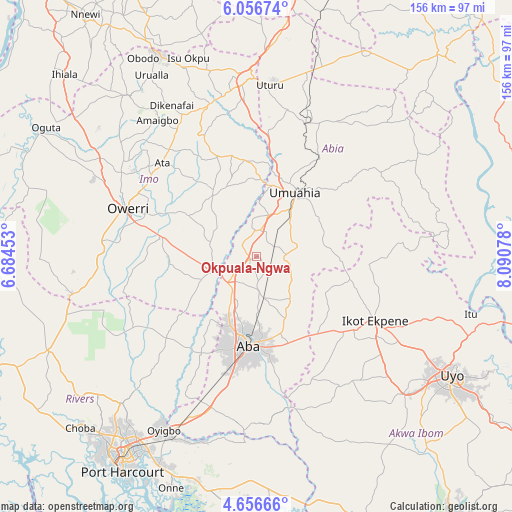
| Upper-left | 6.05674°, | 6.68453° |
| Center: | 5.3571°, | 7.38765° |
| Lower-right: | 4.65666°, | 8.09078° |
| Map W x H: | 155.7×155.7 km | = 96.7×96.7mi |
| max Lat: | 13.7543° ⇑91% North |
| Okpuala-Ngwa: | 5.3571° |
| min Lat: | ⇓9% South 4.31231° |
| min Long | Okpuala-Ngwa | max Long |
| 2.73333° | 7.38765° | 14.46552° |
| W 51.2%⇐ | ⇒48.8% E |
Elevation
Elevation of Okpuala-Ngwa is 118 m = 387 ft, and this is 178.5 m = 586 ft below average elevation for this country.
| Max E: |
1599 m = 5246 ft | 75.4% |
| Avg. | 296.5 m = 973 ft | |
| Okpuala-Ngwa | 118 m = 387 ft | |
Min E: |
2 m = 7 ft | 24.6% |
See also: Nigeria elevation on elevation.city.
Geographical zone
Okpuala-Ngwa is located in North Torrid zone (between Equator and Tropic of Cancer). Distance of Equator is 595.7 km =370.2 mi to South.| Distance of | km | miles | from Okpuala-Ngwa |
|---|---|---|---|
| North Pole | 9411.4 | 5848 | to North |
| Arctic Circle | 6805.5 | 4228.7 | to North |
| Tropic Cancer | 2010.3 | 1249.1 | to North |
| Equator | 595.7 | 370.2 | to South |


Nearby cities:
15 places around Okpuala-Ngwa: (largest is in red/bold)
• Aba
28 km =17.4 mi,  184°
184°
• Aboh
18.4 km =11.4 mi,  315°
315°
• Afor-Oru
24.3 km =15.1 mi,  327°
327°
• Bende
35.3 km =21.9 mi,  50°
50°
• Eberi
34.1 km =21.2 mi,  209°
209°
• Ibiaku Ntok Okpo
36.2 km =22.5 mi,  98°
98°
• Isiala Oboro
20.7 km =12.9 mi,  74°
74°
• Isinweke
29.6 km =18.4 mi,  351°
351°
• Itu
13.4 km =8.3 mi, 332°
• Nto Edino
23.6 km =14.7 mi,  118°
118°
• Okehi
36.7 km =22.8 mi,  228°
228°
• Omoba
12.9 km =8 mi,  170°
170°
• Osisioma
23.1 km =14.4 mi,  198°
198°
• Umuahia
22.1 km =13.7 mi,  32°
32°
• Umuneke-Ngor
26.2 km =16.3 mi,  264°
264°
Sources, notices
• [Note1] Compared only with cities in Nigeria existing in our database
• [Src1] Map data: © OpenStreetMap contributors (CC-BY-SA)
• [Src2] Other city data from geonames.org with taken over terms of usage.
• [Src3] Geographical zone / Annual Mean Temperature by Robert A. Rohde @ Wikipedia
