Achuapa geodata
Achuapa (León) is a seat of a second-order administrative division; located in Nicaragua in America/Managua (GMT-6) time zone. With population of 3,299 people, there are 91 cities with bigger population in this country. Compared to other cities in Nicaragua, 68.3% of cities are located further ↓South; 83.8% of cities are located further →East and 54.5% of cities have lower elevation than Achuapa. Note1


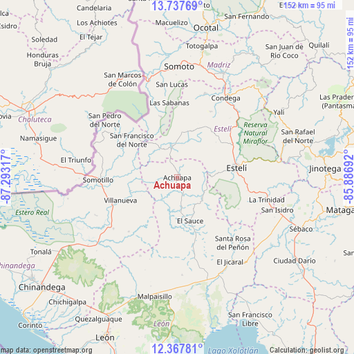
Achuapa GPS coordinates[2]
13° 3' 13.32" North, 86° 35' 24.144" West
| Map corner | latitude | longitude |
|---|---|---|
| Upper-left | 13.73769°, | -87.29317° |
| Center: | 13.0537°, | -86.59004° |
| Lower-right: | 12.36781°, | -85.88692° |
| Map W x H: | 152.3×152.3 km | = 94.6×94.6mi |
| max Lat: | 14.74189° ⇑31.7% North |
| Achuapa: | 13.0537° |
| min Lat: | ⇓68.3% South 10.94684° |
| min Long | Achuapa | max Long |
| -87.4516° | -86.59004° | -83.06145° |
| W 16.2%⇐ | ⇒83.8% E |
Elevation
Elevation of Achuapa is 319 m = 1047 ft, and this is 18.2 m = 60 ft below average elevation for this country.
| Max E: |
1288 m = 4226 ft | 45.5% |
| Avg. | 337.2 m = 1106 ft | |
| Achuapa | 319 m = 1047 ft | |
Min E: |
1 m = 3 ft | 54.5% |
See also: Nicaragua elevation on elevation.city.
Geographical zone
Achuapa is located in North Torrid zone (between Equator and Tropic of Cancer). Distance of this Northern Tropic circle is 1154.5 km =717.4 mi to North.| Distance of | km | miles | from Achuapa |
|---|---|---|---|
| North Pole | 8555.6 | 5316.2 | to North |
| Arctic Circle | 5949.7 | 3697 | to North |
| Tropic Cancer | 1154.5 | 717.4 | to North |
| Equator | 1451.4 | 901.9 | to South |


Nearby cities:
15 places around Achuapa: (largest is in red/bold)
• Cinco Pinos
35.9 km =22.3 mi,  303°
303°
• El Sauce
19.4 km =12.1 mi,  163°
163°
• Estelí
25.9 km =16.1 mi,  80°
80°
• La Trinidad
39.6 km =24.6 mi,  103°
103°
• Las Sabanas
32.4 km =20.1 mi,  353°
353°
• Pueblo Nuevo
38.1 km =23.7 mi,  18°
18°
• San Francisco del Norte
25.4 km =15.8 mi,  309°
309°
• San José de Cusmapa
27 km =16.8 mi,  344°
344°
• San Juan de Limay
13.8 km =8.6 mi, 349°
• San Nicolás
29.5 km =18.3 mi,  117°
117°
• San Pedro del Norte
39.8 km =24.7 mi, 308°
• Santa Rosa del Peñón
36.8 km =22.9 mi,  139°
139°
• Santo Tomás del Norte
38.9 km =24.2 mi,  292°
292°
• Somotillo
34.1 km =21.2 mi,  268°
268°
• Villanueva
26.4 km =16.4 mi,  247°
247°
Sources, notices
• [Note1] Compared only with cities in Nicaragua existing in our database
• [Src1] Map data: © OpenStreetMap contributors (CC-BY-SA)
• [Src2] Other city data from geonames.org with taken over terms of usage.
• [Src3] Geographical zone / Annual Mean Temperature by Robert A. Rohde @ Wikipedia
