San Juan de Limay geodata
San Juan de Limay (Estelí) is a seat of a second-order administrative division; located in Nicaragua in America/Managua (GMT-6) time zone. With population of 4,997 people, there are 77 cities with bigger population in this country. Compared to other cities in Nicaragua, 72.5% of cities are located further ↓South; 85% of cities are located further →East and 50.9% of cities have higher elevation than San Juan de Limay. Note1


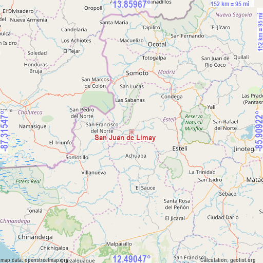
San Juan de Limay GPS coordinates[2]
13° 10' 33.708" North, 86° 36' 44.424" West
| Map corner | latitude | longitude |
|---|---|---|
| Upper-left | 13.85967°, | -87.31547° |
| Center: | 13.17603°, | -86.61234° |
| Lower-right: | 12.49047°, | -85.90922° |
| Map W x H: | 152.2×152.2 km | = 94.6×94.6mi |
| max Lat: | 14.74189° ⇑27.5% North |
| San Juan de Limay: | 13.17603° |
| min Lat: | ⇓72.5% South 10.94684° |
| min Long | San Juan de Lim | max Long |
| -87.4516° | -86.61234° | -83.06145° |
| W 15%⇐ | ⇒85% E |
Elevation
Elevation of San Juan de Limay is 284 m = 932 ft, and this is 53.2 m = 175 ft below average elevation for this country.
| Max E: |
1288 m = 4226 ft | 50.9% |
| Avg. | 337.2 m = 1106 ft | |
| San Juan de Limay | 284 m = 932 ft | |
Min E: |
1 m = 3 ft | 49.1% |
See also: Nicaragua elevation on elevation.city.
Geographical zone
San Juan de Limay is located in North Torrid zone (between Equator and Tropic of Cancer). Distance of this Northern Tropic circle is 1140.9 km =708.9 mi to North.| Distance of | km | miles | from San Juan de Limay |
|---|---|---|---|
| North Pole | 8542 | 5307.8 | to North |
| Arctic Circle | 5936.1 | 3688.5 | to North |
| Tropic Cancer | 1140.9 | 708.9 | to North |
| Equator | 1465 | 910.3 | to South |


Nearby cities:
15 places around San Juan de Limay: (largest is in red/bold)
• Achuapa
13.8 km =8.6 mi,  169°
169°
• Cinco Pinos
28.3 km =17.6 mi,  282°
282°
• Condega
31.3 km =19.4 mi,  47°
47°
• El Sauce
33.1 km =20.6 mi, 166°
• Estelí
29.5 km =18.3 mi,  108°
108°
• Las Sabanas
18.6 km =11.6 mi,  356°
356°
• Pueblo Nuevo
26.8 km =16.7 mi,  32°
32°
• San Francisco del Norte
17.4 km =10.8 mi, 278°
• San José de Cusmapa
13.3 km =8.3 mi,  339°
339°
• San Lucas
26.4 km =16.4 mi,  0°
0°
• San Pedro del Norte
30.8 km =19.1 mi,  291°
291°
• Santo Tomás del Norte
33.6 km =20.9 mi,  271°
271°
• Somotillo
34.9 km =21.7 mi,  245°
245°
• Somoto
34 km =21.1 mi,  5°
5°
• Villanueva
32.3 km =20.1 mi,  222°
222°
Sources, notices
• [Note1] Compared only with cities in Nicaragua existing in our database
• [Src1] Map data: © OpenStreetMap contributors (CC-BY-SA)
• [Src2] Other city data from geonames.org with taken over terms of usage.
• [Src3] Geographical zone / Annual Mean Temperature by Robert A. Rohde @ Wikipedia
