Villa El Carmen geodata
Villa El Carmen (Managua) is a seat of a second-order administrative division; located in Nicaragua in America/Managua (GMT-6) time zone. With population of 5,219 people, there are 74 cities with bigger population in this country. Compared to other cities in Nicaragua, 74.3% of cities are located further ↑North; 79.6% of cities are located further →East and 68.9% of cities have higher elevation than Villa El Carmen. Note1


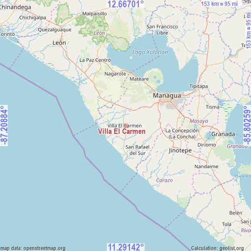
Villa El Carmen GPS coordinates[2]
11° 58' 48.324" North, 86° 30' 20.556" West
| Map corner | latitude | longitude |
|---|---|---|
| Upper-left | 12.66701°, | -87.20884° |
| Center: | 11.98009°, | -86.50571° |
| Lower-right: | 11.29142°, | -85.80259° |
| Map W x H: | 153×153 km | = 95.1×95.1mi |
| max Lat: | 14.74189° ⇑74.3% North |
| Villa El Carmen: | 11.98009° |
| min Lat: | ⇓25.7% South 10.94684° |
| min Long | Villa El Carmen | max Long |
| -87.4516° | -86.50571° | -83.06145° |
| W 20.4%⇐ | ⇒79.6% E |
Elevation
Elevation of Villa El Carmen is 107 m = 351 ft, and this is 230.2 m = 755 ft below average elevation for this country.
| Max E: |
1288 m = 4226 ft | 68.9% |
| Avg. | 337.2 m = 1106 ft | |
| Villa El Carmen | 107 m = 351 ft | |
Min E: |
1 m = 3 ft | 31.1% |
See also: Nicaragua elevation on elevation.city.
Geographical zone
Villa El Carmen is located in North Torrid zone (between Equator and Tropic of Cancer). Distance of this Northern Tropic circle is 1273.9 km =791.6 mi to North.| Distance of | km | miles | from Villa El Carmen |
|---|---|---|---|
| North Pole | 8675 | 5390.4 | to North |
| Arctic Circle | 6069.1 | 3771.2 | to North |
| Tropic Cancer | 1273.9 | 791.6 | to North |
| Equator | 1332.1 | 827.7 | to South |


Nearby cities:
15 places around Villa El Carmen: (largest is in red/bold)
• Ciudad Sandino
26.5 km =16.5 mi,  41°
41°
• Diriamba
32 km =19.9 mi,  115°
115°
• Dolores
34.4 km =21.4 mi,  113°
113°
• El Crucero
21.4 km =13.3 mi,  87°
87°
• El Rosario
26.7 km =16.6 mi,  147°
147°
• Jinotepe
36.4 km =22.6 mi, 113°
• La Concepción
34.7 km =21.6 mi,  97°
97°
• Managua
32.5 km =20.2 mi,  58°
58°
• Masachapa
21.5 km =13.4 mi,  182°
182°
• Masatepe
40 km =24.9 mi, 100°
• Mateare
29.6 km =18.4 mi,  16°
16°
• Nagarote
32.4 km =20.1 mi,  348°
348°
• San Marcos
33.8 km =21 mi, 103°
• San Rafael del Sur
16.4 km =10.2 mi, 153°
• Ticuantepe
33.1 km =20.6 mi,  81°
81°
Sources, notices
• [Note1] Compared only with cities in Nicaragua existing in our database
• [Src1] Map data: © OpenStreetMap contributors (CC-BY-SA)
• [Src2] Other city data from geonames.org with taken over terms of usage.
• [Src3] Geographical zone / Annual Mean Temperature by Robert A. Rohde @ Wikipedia
