Zondveld geodata
Zondveld (North Brabant) is a populated place; located in Netherlands in Europe/Amsterdam (GMT+2) time zone. With population of 540 people, there are 1788 cities with bigger population in this country. Compared to other cities in Netherlands, 75.4% of cities are located further ↑North; 54.4% of cities are located further →East and 64.6% of cities have lower elevation than Zondveld. Note1


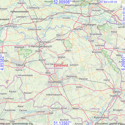
Zondveld GPS coordinates[2]
51° 34' 27.012" North, 5° 33' 24.984" East
| Map corner | latitude | longitude |
|---|---|---|
| Upper-left | 52.00906°, | 4.85382° |
| Center: | 51.57417°, | 5.55694° |
| Lower-right: | 51.13507°, | 6.26007° |
| Map W x H: | 97.2×97.2 km | = 60.4×60.4mi |
| max Lat: | 53.48025° ⇑75.4% North |
| Zondveld: | 51.57417° |
| min Lat: | ⇓24.6% South 50.76917° |
| min Long | Zondveld | max Long |
| 3.38611° | 5.55694° | 7.16528° |
| W 45.6%⇐ | ⇒54.4% E |
Elevation
Elevation of Zondveld is 12 m = 39 ft, and this is 3 m = 10 ft below average elevation for this country.
| Max E: |
203 m = 666 ft | 35.4% |
| Avg. | 15 m = 49 ft | |
| Zondveld | 12 m = 39 ft | |
Min E: |
-6 m = -20 ft | 64.6% |
See also: Netherlands elevation on elevation.city.
Geographical zone
Zondveld is located in North temperate zone (between Tropic of Cancer and the Arctic Circle). Distance of this North polar circle is 1666.7 km =1035.6 mi to North.| Distance of | km | miles | from Zondveld |
|---|---|---|---|
| North Pole | 4272.6 | 2654.9 | to North |
| Arctic Circle | 1666.7 | 1035.6 | to North |
| Tropic Cancer | 3128.6 | 1944 | to South |
| Equator | 5734.5 | 3563.3 | to South |


Nearby cities:
15 places around Zondveld: (largest is in red/bold)
• Boerdonk
5 km =3.1 mi,  109°
109°
• Breugel
7.1 km =4.4 mi,  206°
206°
• Donk
6.4 km =4 mi,  128°
128°
• Eerde
5.2 km =3.2 mi,  309°
309°
• Eerschot
5.8 km =3.6 mi,  263°
263°
• Erp
4.5 km =2.8 mi,  50°
50°
• Keldonk
2.4 km =1.5 mi, 54°
• Leest
4.1 km =2.5 mi,  346°
346°
• Lieshout
6.5 km =4 mi,  156°
156°
• Mariaheide
6.8 km =4.2 mi,  13°
13°
• Mariahout
3.9 km =2.4 mi, 164°
• Nijnsel
5.7 km =3.5 mi,  242°
242°
• Sint-Oedenrode
6.8 km =4.2 mi, 263°
• Veghel
4.8 km =3 mi, 353°
• Zijtaart
2.3 km =1.4 mi,  332°
332°
Sources, notices
• [Note1] Compared only with cities in Netherlands existing in our database
• [Src1] Map data: © OpenStreetMap contributors (CC-BY-SA)
• [Src2] Other city data from geonames.org with taken over terms of usage.
• [Src3] Geographical zone / Annual Mean Temperature by Robert A. Rohde @ Wikipedia
