Lieshout geodata
Lieshout (North Brabant) is a populated place; located in Netherlands in Europe/Amsterdam (GMT+2) time zone. With population of 3,530 people, there are 668 cities with bigger population in this country. Compared to other cities in Netherlands, 79.2% of cities are located further ↑North; 52.6% of cities are located further →East and 70.6% of cities have lower elevation than Lieshout. Note1


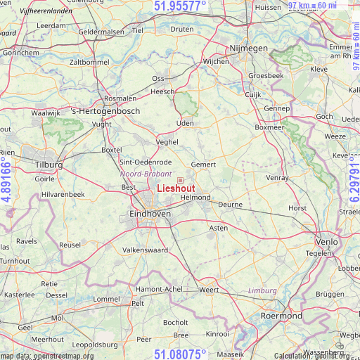
Lieshout GPS coordinates[2]
51° 31' 13.296" North, 5° 35' 41.244" East
| Map corner | latitude | longitude |
|---|---|---|
| Upper-left | 51.95577°, | 4.89166° |
| Center: | 51.52036°, | 5.59479° |
| Lower-right: | 51.08075°, | 6.29791° |
| Map W x H: | 97.3×97.3 km | = 60.5×60.5mi |
| max Lat: | 53.48025° ⇑79.2% North |
| Lieshout: | 51.52036° |
| min Lat: | ⇓20.8% South 50.76917° |
| min Long | Lieshout | max Long |
| 3.38611° | 5.59479° | 7.16528° |
| W 47.4%⇐ | ⇒52.6% E |
Elevation
Elevation of Lieshout is 15 m = 49 ft, and this is 0 m = 0 ft above average elevation for this country.
| Max E: |
203 m = 666 ft | 29.4% |
| Lieshout | 15 m 49 ft | |
| Avg. | 15 m = 49 ft | |
Min E: |
-6 m = -20 ft | 70.6% |
See also: Netherlands elevation on elevation.city.
Geographical zone
Lieshout is located in North temperate zone (between Tropic of Cancer and the Arctic Circle). Distance of this North polar circle is 1672.6 km =1039.3 mi to North.| Distance of | km | miles | from Lieshout |
|---|---|---|---|
| North Pole | 4278.5 | 2658.5 | to North |
| Arctic Circle | 1672.6 | 1039.3 | to North |
| Tropic Cancer | 3122.6 | 1940.3 | to South |
| Equator | 5728.5 | 3559.5 | to South |


Nearby cities:
15 places around Lieshout: (largest is in red/bold)
• Aarle-Rixtel
3.2 km =2 mi,  111°
111°
• Beek
2.9 km =1.8 mi,  70°
70°
• Boerdonk
4.8 km =3 mi,  25°
25°
• Brand
7.2 km =4.5 mi,  163°
163°
• Breugel
5.8 km =3.6 mi,  266°
266°
• Donk
3.1 km =1.9 mi,  49°
49°
• Gerwen
4 km =2.5 mi,  213°
213°
• Helmond
6.3 km =3.9 mi,  133°
133°
• Mariahout
2.8 km =1.7 mi,  325°
325°
• Nederwetten
5.9 km =3.7 mi,  237°
237°
• Nuenen
6.3 km =3.9 mi, 207°
• Schutsboom
6.8 km =4.2 mi, 163°
• Son
7.1 km =4.4 mi,  261°
261°
• Son en Breugel
6.8 km =4.2 mi, 266°
• Zondveld
6.5 km =4 mi,  336°
336°
Sources, notices
• [Note1] Compared only with cities in Netherlands existing in our database
• [Src1] Map data: © OpenStreetMap contributors (CC-BY-SA)
• [Src2] Other city data from geonames.org with taken over terms of usage.
• [Src3] Geographical zone / Annual Mean Temperature by Robert A. Rohde @ Wikipedia
