Keldonk geodata
Keldonk (North Brabant) is a populated place; located in Netherlands in Europe/Amsterdam (GMT+2) time zone. With population of 725 people, there are 1594 cities with bigger population in this country. Compared to other cities in Netherlands, 74.6% of cities are located further ↑North; 53.1% of cities are located further →East and 64.6% of cities have lower elevation than Keldonk. Note1


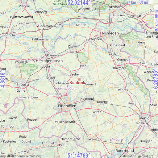
Keldonk GPS coordinates[2]
51° 35' 12.012" North, 5° 35' 4.992" East
| Map corner | latitude | longitude |
|---|---|---|
| Upper-left | 52.02144°, | 4.8816° |
| Center: | 51.58667°, | 5.58472° |
| Lower-right: | 51.14769°, | 6.28785° |
| Map W x H: | 97.2×97.1 km | = 60.4×60.3mi |
| max Lat: | 53.48025° ⇑74.6% North |
| Keldonk: | 51.58667° |
| min Lat: | ⇓25.4% South 50.76917° |
| min Long | Keldonk | max Long |
| 3.38611° | 5.58472° | 7.16528° |
| W 46.9%⇐ | ⇒53.1% E |
Elevation
Elevation of Keldonk is 12 m = 39 ft, and this is 3 m = 10 ft below average elevation for this country.
| Max E: |
203 m = 666 ft | 35.4% |
| Avg. | 15 m = 49 ft | |
| Keldonk | 12 m = 39 ft | |
Min E: |
-6 m = -20 ft | 64.6% |
See also: Netherlands elevation on elevation.city.
Geographical zone
Keldonk is located in North temperate zone (between Tropic of Cancer and the Arctic Circle). Distance of this North polar circle is 1665.3 km =1034.8 mi to North.| Distance of | km | miles | from Keldonk |
|---|---|---|---|
| North Pole | 4271.2 | 2654 | to North |
| Arctic Circle | 1665.3 | 1034.8 | to North |
| Tropic Cancer | 3130 | 1944.9 | to South |
| Equator | 5735.9 | 3564.1 | to South |


Nearby cities:
15 places around Keldonk: (largest is in red/bold)
• Beek
7.3 km =4.5 mi,  152°
152°
• Boekel
6.5 km =4 mi,  73°
73°
• Boerdonk
4.1 km =2.5 mi,  137°
137°
• Donk
6.2 km =3.9 mi, 150°
• Eerde
6.3 km =3.9 mi,  288°
288°
• Eikenheuvel
6.1 km =3.8 mi,  17°
17°
• Erp
2.1 km =1.3 mi,  46°
46°
• Leest
3.9 km =2.4 mi,  311°
311°
• Lieshout
7.4 km =4.6 mi,  174°
174°
• Mariaheide
5.2 km =3.2 mi,  356°
356°
• Mariahout
5.2 km =3.2 mi,  189°
189°
• Veghel
4.2 km =2.6 mi,  323°
323°
• Ven
6.4 km =4 mi,  337°
337°
• Zijtaart
3 km =1.9 mi,  282°
282°
• Zondveld
2.4 km =1.5 mi,  234°
234°
Sources, notices
• [Note1] Compared only with cities in Netherlands existing in our database
• [Src1] Map data: © OpenStreetMap contributors (CC-BY-SA)
• [Src2] Other city data from geonames.org with taken over terms of usage.
• [Src3] Geographical zone / Annual Mean Temperature by Robert A. Rohde @ Wikipedia
