Mariahout geodata
Mariahout (North Brabant) is a populated place; located in Netherlands in Europe/Amsterdam (GMT+2) time zone. With population of 1,130 people, there are 1314 cities with bigger population in this country. Compared to other cities in Netherlands, 77.6% of cities are located further ↑North; 53.6% of cities are located further →East and 70.6% of cities have lower elevation than Mariahout. Note1


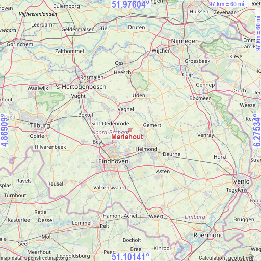
Mariahout GPS coordinates[2]
51° 32' 26.988" North, 5° 34' 19.992" East
| Map corner | latitude | longitude |
|---|---|---|
| Upper-left | 51.97604°, | 4.86909° |
| Center: | 51.54083°, | 5.57222° |
| Lower-right: | 51.10141°, | 6.27534° |
| Map W x H: | 97.2×97.2 km | = 60.4×60.4mi |
| max Lat: | 53.48025° ⇑77.6% North |
| Mariahout: | 51.54083° |
| min Lat: | ⇓22.4% South 50.76917° |
| min Long | Mariahout | max Long |
| 3.38611° | 5.57222° | 7.16528° |
| W 46.4%⇐ | ⇒53.6% E |
Elevation
Elevation of Mariahout is 15 m = 49 ft, and this is 0 m = 0 ft above average elevation for this country.
| Max E: |
203 m = 666 ft | 29.4% |
| Mariahout | 15 m 49 ft | |
| Avg. | 15 m = 49 ft | |
Min E: |
-6 m = -20 ft | 70.6% |
See also: Netherlands elevation on elevation.city.
Geographical zone
Mariahout is located in North temperate zone (between Tropic of Cancer and the Arctic Circle). Distance of this North polar circle is 1670.4 km =1037.9 mi to North.| Distance of | km | miles | from Mariahout |
|---|---|---|---|
| North Pole | 4276.3 | 2657.2 | to North |
| Arctic Circle | 1670.4 | 1037.9 | to North |
| Tropic Cancer | 3124.9 | 1941.7 | to South |
| Equator | 5730.8 | 3561 | to South |


Nearby cities:
15 places around Mariahout: (largest is in red/bold)
• Aarle-Rixtel
5.7 km =3.5 mi,  127°
127°
• Beek
4.5 km =2.8 mi,  107°
107°
• Boerdonk
4.2 km =2.6 mi,  60°
60°
• Breugel
5 km =3.1 mi,  238°
238°
• Donk
3.9 km =2.4 mi,  93°
93°
• Erp
7 km =4.3 mi,  20°
20°
• Gerwen
5.7 km =3.5 mi,  186°
186°
• Keldonk
5.2 km =3.2 mi,  9°
9°
• Lieshout
2.8 km =1.7 mi,  145°
145°
• Nederwetten
6.4 km =4 mi,  211°
211°
• Nijnsel
6.2 km =3.9 mi,  280°
280°
• Son
6.4 km =4 mi, 239°
• Son en Breugel
5.9 km =3.7 mi, 242°
• Zijtaart
6.1 km =3.8 mi,  339°
339°
• Zondveld
3.9 km =2.4 mi, 344°
Sources, notices
• [Note1] Compared only with cities in Netherlands existing in our database
• [Src1] Map data: © OpenStreetMap contributors (CC-BY-SA)
• [Src2] Other city data from geonames.org with taken over terms of usage.
• [Src3] Geographical zone / Annual Mean Temperature by Robert A. Rohde @ Wikipedia
