Breugel geodata
Breugel (North Brabant) is a populated place; located in Netherlands in Europe/Amsterdam (GMT+2) time zone. With population of 1,055 people, there are 1360 cities with bigger population in this country. Compared to other cities in Netherlands, 79.5% of cities are located further ↑North; 56.1% of cities are located further →East and 73.5% of cities have lower elevation than Breugel. Note1


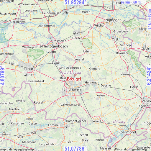
Breugel GPS coordinates[2]
51° 31' 3" North, 5° 30' 39.996" East
| Map corner | latitude | longitude |
|---|---|---|
| Upper-left | 51.95294°, | 4.80799° |
| Center: | 51.5175°, | 5.51111° |
| Lower-right: | 51.07786°, | 6.21424° |
| Map W x H: | 97.3×97.3 km | = 60.5×60.5mi |
| max Lat: | 53.48025° ⇑79.5% North |
| Breugel: | 51.5175° |
| min Lat: | ⇓20.5% South 50.76917° |
| min Long | Breugel | max Long |
| 3.38611° | 5.51111° | 7.16528° |
| W 43.9%⇐ | ⇒56.1% E |
Elevation
Elevation of Breugel is 17 m = 56 ft, and this is 2 m = 7 ft above average elevation for this country.
| Max E: |
203 m = 666 ft | 26.5% |
| Breugel | 17 m 56 ft | |
| Avg. | 15 m = 49 ft | |
Min E: |
-6 m = -20 ft | 73.5% |
See also: Netherlands elevation on elevation.city.
Geographical zone
Breugel is located in North temperate zone (between Tropic of Cancer and the Arctic Circle). Distance of this North polar circle is 1673 km =1039.6 mi to North.| Distance of | km | miles | from Breugel |
|---|---|---|---|
| North Pole | 4278.9 | 2658.8 | to North |
| Arctic Circle | 1673 | 1039.6 | to North |
| Tropic Cancer | 3122.3 | 1940.1 | to South |
| Equator | 5728.2 | 3559.3 | to South |


Nearby cities:
15 places around Breugel: (largest is in red/bold)
• Eckart
5.1 km =3.2 mi,  193°
193°
• Eerschot
6.2 km =3.9 mi,  335°
335°
• Gerwen
4.7 km =2.9 mi,  130°
130°
• Heesterakker
3.6 km =2.2 mi,  195°
195°
• Jagershoef
5.8 km =3.6 mi,  211°
211°
• Lieshout
5.8 km =3.6 mi,  86°
86°
• Mariahout
5 km =3.1 mi,  58°
58°
• Nederwetten
3 km =1.9 mi,  163°
163°
• Nijnsel
4.2 km =2.6 mi,  332°
332°
• Nuenen
6 km =3.7 mi,  151°
151°
• Son
1.4 km =0.9 mi,  241°
241°
• Son en Breugel
1 km =0.6 mi,  264°
264°
• Vaartbroek
4.3 km =2.7 mi, 192°
• Vlokhoven
6 km =3.7 mi, 198°
• Woenselse Heide
4.9 km =3 mi,  218°
218°
Sources, notices
• [Note1] Compared only with cities in Netherlands existing in our database
• [Src1] Map data: © OpenStreetMap contributors (CC-BY-SA)
• [Src2] Other city data from geonames.org with taken over terms of usage.
• [Src3] Geographical zone / Annual Mean Temperature by Robert A. Rohde @ Wikipedia
