Nijnsel geodata
Nijnsel (North Brabant) is a populated place; located in Netherlands in Europe/Amsterdam (GMT+2) time zone. With population of 1,405 people, there are 1178 cities with bigger population in this country. Compared to other cities in Netherlands, 76.8% of cities are located further ↑North; 57.5% of cities are located further →East and 69% of cities have lower elevation than Nijnsel. Note1


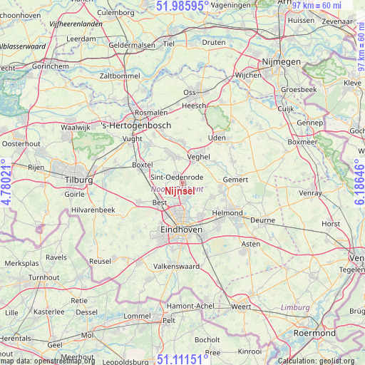
Nijnsel GPS coordinates[2]
51° 33' 2.988" North, 5° 28' 59.988" East
| Map corner | latitude | longitude |
|---|---|---|
| Upper-left | 51.98595°, | 4.78021° |
| Center: | 51.55083°, | 5.48333° |
| Lower-right: | 51.11151°, | 6.18646° |
| Map W x H: | 97.2×97.2 km | = 60.4×60.4mi |
| max Lat: | 53.48025° ⇑76.8% North |
| Nijnsel: | 51.55083° |
| min Lat: | ⇓23.2% South 50.76917° |
| min Long | Nijnsel | max Long |
| 3.38611° | 5.48333° | 7.16528° |
| W 42.5%⇐ | ⇒57.5% E |
Elevation
Elevation of Nijnsel is 14 m = 46 ft, and this is 1 m = 3 ft below average elevation for this country.
| Max E: |
203 m = 666 ft | 31% |
| Avg. | 15 m = 49 ft | |
| Nijnsel | 14 m = 46 ft | |
Min E: |
-6 m = -20 ft | 69% |
See also: Netherlands elevation on elevation.city.
Geographical zone
Nijnsel is located in North temperate zone (between Tropic of Cancer and the Arctic Circle). Distance of this North polar circle is 1669.3 km =1037.3 mi to North.| Distance of | km | miles | from Nijnsel |
|---|---|---|---|
| North Pole | 4275.1 | 2656.4 | to North |
| Arctic Circle | 1669.3 | 1037.3 | to North |
| Tropic Cancer | 3126 | 1942.4 | to South |
| Equator | 5731.9 | 3561.6 | to South |


Nearby cities:
15 places around Nijnsel: (largest is in red/bold)
• Boskant
4.3 km =2.7 mi,  268°
268°
• Breugel
4.2 km =2.6 mi,  152°
152°
• Eerde
6 km =3.7 mi,  10°
10°
• Eerschot
2.1 km =1.3 mi,  340°
340°
• Heesterakker
7.3 km =4.5 mi,  172°
172°
• Mariahout
6.2 km =3.9 mi,  100°
100°
• Nederwetten
7.1 km =4.4 mi,  157°
157°
• Olland
6.2 km =3.9 mi,  302°
302°
• Sint-Oedenrode
2.5 km =1.6 mi,  318°
318°
• Son
4.4 km =2.7 mi, 171°
• Son en Breugel
3.9 km =2.4 mi, 166°
• Speelheide
7.3 km =4.5 mi,  227°
227°
• Wijbosch
7.4 km =4.6 mi,  351°
351°
• Zijtaart
6.1 km =3.8 mi,  41°
41°
• Zondveld
5.7 km =3.5 mi,  62°
62°
Sources, notices
• [Note1] Compared only with cities in Netherlands existing in our database
• [Src1] Map data: © OpenStreetMap contributors (CC-BY-SA)
• [Src2] Other city data from geonames.org with taken over terms of usage.
• [Src3] Geographical zone / Annual Mean Temperature by Robert A. Rohde @ Wikipedia
