Herpen geodata
Herpen (North Brabant) is a populated place; located in Netherlands in Europe/Amsterdam (GMT+2) time zone. With population of 2,360 people, there are 878 cities with bigger population in this country. Compared to other cities in Netherlands, 65.8% of cities are located further ↑North; 50.5% of cities are located further →East and 59.4% of cities have lower elevation than Herpen. Note1


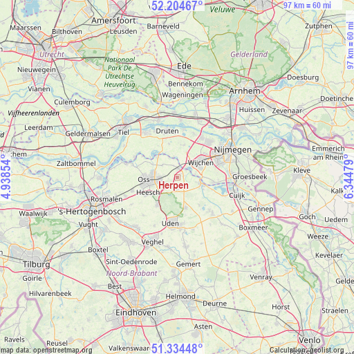
Herpen GPS coordinates[2]
51° 46' 18.012" North, 5° 38' 30.012" East
| Map corner | latitude | longitude |
|---|---|---|
| Upper-left | 52.20467°, | 4.93854° |
| Center: | 51.77167°, | 5.64167° |
| Lower-right: | 51.33448°, | 6.34479° |
| Map W x H: | 96.8×96.8 km | = 60.1×60.1mi |
| max Lat: | 53.48025° ⇑65.8% North |
| Herpen: | 51.77167° |
| min Lat: | ⇓34.2% South 50.76917° |
| min Long | Herpen | max Long |
| 3.38611° | 5.64167° | 7.16528° |
| W 49.5%⇐ | ⇒50.5% E |
Elevation
Elevation of Herpen is 10 m = 33 ft, and this is 5 m = 16 ft below average elevation for this country.
| Max E: |
203 m = 666 ft | 40.6% |
| Avg. | 15 m = 49 ft | |
| Herpen | 10 m = 33 ft | |
Min E: |
-6 m = -20 ft | 59.4% |
See also: Netherlands elevation on elevation.city.
Geographical zone
Herpen is located in North temperate zone (between Tropic of Cancer and the Arctic Circle). Distance of this North polar circle is 1644.7 km =1022 mi to North.| Distance of | km | miles | from Herpen |
|---|---|---|---|
| North Pole | 4250.6 | 2641.2 | to North |
| Arctic Circle | 1644.7 | 1022 | to North |
| Tropic Cancer | 3150.6 | 1957.7 | to South |
| Equator | 5756.5 | 3576.9 | to South |


Nearby cities:
15 places around Herpen: (largest is in red/bold)
• Batenburg
5.9 km =3.7 mi,  351°
351°
• Berghem
5.1 km =3.2 mi,  267°
267°
• Grave
6.8 km =4.2 mi,  101°
101°
• Haren
5.1 km =3.2 mi,  310°
310°
• Hernen
7.4 km =4.6 mi,  21°
21°
• Macharen
7.7 km =4.8 mi,  299°
299°
• Megen
7.8 km =4.8 mi,  315°
315°
• Nederasselt
7.1 km =4.4 mi,  90°
90°
• Oss
8.5 km =5.3 mi, 265°
• Ravenstein
2.8 km =1.7 mi,  11°
11°
• Reek
4 km =2.5 mi,  136°
136°
• Schaijk
3 km =1.9 mi,  193°
193°
• Valendries
7.5 km =4.7 mi,  58°
58°
• Wijchen
7.1 km =4.4 mi,  53°
53°
• Zeeland
8.6 km =5.3 mi,  163°
163°
Sources, notices
• [Note1] Compared only with cities in Netherlands existing in our database
• [Src1] Map data: © OpenStreetMap contributors (CC-BY-SA)
• [Src2] Other city data from geonames.org with taken over terms of usage.
• [Src3] Geographical zone / Annual Mean Temperature by Robert A. Rohde @ Wikipedia
