Wilbertoord geodata
Wilbertoord (North Brabant) is a populated place; located in Netherlands in Europe/Amsterdam (GMT+2) time zone. With population of 785 people, there are 1537 cities with bigger population in this country. Compared to other cities in Netherlands, 71.1% of cities are located further ↑North; 56.1% of cities are located further ←West and 78.8% of cities have lower elevation than Wilbertoord. Note1


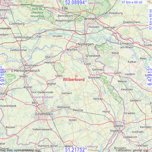
Wilbertoord GPS coordinates[2]
51° 39' 20.988" North, 5° 46' 30" East
| Map corner | latitude | longitude |
|---|---|---|
| Upper-left | 52.08994°, | 5.07188° |
| Center: | 51.65583°, | 5.775° |
| Lower-right: | 51.21752°, | 6.47813° |
| Map W x H: | 97×97 km | = 60.3×60.3mi |
| max Lat: | 53.48025° ⇑71.1% North |
| Wilbertoord: | 51.65583° |
| min Lat: | ⇓28.9% South 50.76917° |
| min Long | Wilbertoord | max Long |
| 3.38611° | 5.775° | 7.16528° |
| W 56.1%⇐ | ⇒43.9% E |
Elevation
Elevation of Wilbertoord is 20 m = 66 ft, and this is 5 m = 16 ft above average elevation for this country.
| Max E: |
203 m = 666 ft | 21.2% |
| Wilbertoord | 20 m 66 ft | |
| Avg. | 15 m = 49 ft | |
Min E: |
-6 m = -20 ft | 78.8% |
See also: Netherlands elevation on elevation.city.
Geographical zone
Wilbertoord is located in North temperate zone (between Tropic of Cancer and the Arctic Circle). Distance of this North polar circle is 1657.6 km =1030 mi to North.| Distance of | km | miles | from Wilbertoord |
|---|---|---|---|
| North Pole | 4263.5 | 2649.2 | to North |
| Arctic Circle | 1657.6 | 1030 | to North |
| Tropic Cancer | 3137.7 | 1949.7 | to South |
| Equator | 5743.6 | 3568.9 | to South |


Nearby cities:
15 places around Wilbertoord: (largest is in red/bold)
• Beers
8.6 km =5.3 mi,  25°
25°
• Boekel
9 km =5.6 mi,  229°
229°
• Elsendorp
8.3 km =5.2 mi,  182°
182°
• Handel
9.6 km =6 mi,  208°
208°
• Haps
7 km =4.3 mi,  58°
58°
• Langenboom
6.2 km =3.9 mi,  330°
330°
• Odiliapeel
5 km =3.1 mi,  253°
253°
• Oploo
8.6 km =5.3 mi,  127°
127°
• Sint Anthonis
8.1 km =5 mi,  113°
113°
• Sint Hubert
3.4 km =2.1 mi,  42°
42°
• Venhorst
5.9 km =3.7 mi, 206°
• Vianen
9 km =5.6 mi, 39°
• Volkel
8.5 km =5.3 mi,  259°
259°
• Wanroij
3 km =1.9 mi,  86°
86°
• Zeeland
8.2 km =5.1 mi,  304°
304°
Sources, notices
• [Note1] Compared only with cities in Netherlands existing in our database
• [Src1] Map data: © OpenStreetMap contributors (CC-BY-SA)
• [Src2] Other city data from geonames.org with taken over terms of usage.
• [Src3] Geographical zone / Annual Mean Temperature by Robert A. Rohde @ Wikipedia
