Reek geodata
Reek (North Brabant) is a populated place; located in Netherlands in Europe/Amsterdam (GMT+2) time zone. With population of 1,495 people, there are 1134 cities with bigger population in this country. Compared to other cities in Netherlands, 67.1% of cities are located further ↑North; 51.3% of cities are located further ←West and 64.6% of cities have lower elevation than Reek. Note1


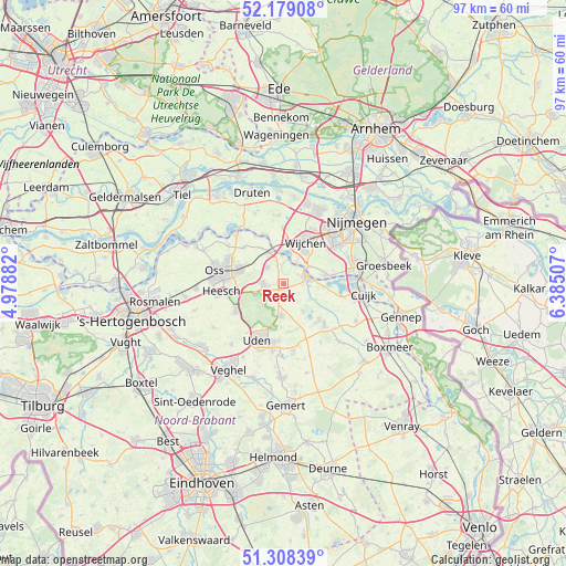
Reek GPS coordinates[2]
51° 44' 44.988" North, 5° 40' 54.984" East
| Map corner | latitude | longitude |
|---|---|---|
| Upper-left | 52.17908°, | 4.97882° |
| Center: | 51.74583°, | 5.68194° |
| Lower-right: | 51.30839°, | 6.38507° |
| Map W x H: | 96.8×96.8 km | = 60.1×60.1mi |
| max Lat: | 53.48025° ⇑67.1% North |
| Reek: | 51.74583° |
| min Lat: | ⇓32.9% South 50.76917° |
| min Long | Reek | max Long |
| 3.38611° | 5.68194° | 7.16528° |
| W 51.3%⇐ | ⇒48.7% E |
Elevation
Elevation of Reek is 12 m = 39 ft, and this is 3 m = 10 ft below average elevation for this country.
| Max E: |
203 m = 666 ft | 35.4% |
| Avg. | 15 m = 49 ft | |
| Reek | 12 m = 39 ft | |
Min E: |
-6 m = -20 ft | 64.6% |
See also: Netherlands elevation on elevation.city.
Geographical zone
Reek is located in North temperate zone (between Tropic of Cancer and the Arctic Circle). Distance of this North polar circle is 1647.6 km =1023.8 mi to North.| Distance of | km | miles | from Reek |
|---|---|---|---|
| North Pole | 4253.5 | 2643 | to North |
| Arctic Circle | 1647.6 | 1023.8 | to North |
| Tropic Cancer | 3147.7 | 1955.9 | to South |
| Equator | 5753.6 | 3575.1 | to South |


Nearby cities:
15 places around Reek: (largest is in red/bold)
• Alverna
8.4 km =5.2 mi,  39°
39°
• Berghem
8.3 km =5.2 mi,  288°
288°
• Grave
4.2 km =2.6 mi,  69°
69°
• Haren
9.1 km =5.7 mi,  312°
312°
• Herpen
4 km =2.5 mi,  316°
316°
• Hoeven
8.8 km =5.5 mi,  201°
201°
• Langenboom
5.7 km =3.5 mi,  144°
144°
• Nederasselt
5.2 km =3.2 mi,  56°
56°
• Nistelrode
9.4 km =5.8 mi,  240°
240°
• Overasselt
7.5 km =4.7 mi,  77°
77°
• Ravenstein
6.1 km =3.8 mi,  338°
338°
• Schaijk
3.4 km =2.1 mi,  270°
270°
• Valendries
7.7 km =4.8 mi,  28°
28°
• Wijchen
7.6 km =4.7 mi,  22°
22°
• Zeeland
5.4 km =3.4 mi,  184°
184°
Sources, notices
• [Note1] Compared only with cities in Netherlands existing in our database
• [Src1] Map data: © OpenStreetMap contributors (CC-BY-SA)
• [Src2] Other city data from geonames.org with taken over terms of usage.
• [Src3] Geographical zone / Annual Mean Temperature by Robert A. Rohde @ Wikipedia
