Rolde geodata
Rolde (Drenthe) is a populated place; located in Netherlands in Europe/Amsterdam (GMT+2) time zone. With population of 3,740 people, there are 633 cities with bigger population in this country. Compared to other cities in Netherlands, 85.1% of cities are located further ↓South; 92.3% of cities are located further ←West and 70.6% of cities have lower elevation than Rolde. Note1


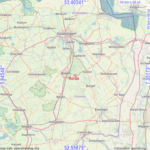
Rolde GPS coordinates[2]
52° 59' 3.012" North, 6° 38' 54.996" East
| Map corner | latitude | longitude |
|---|---|---|
| Upper-left | 53.40541°, | 5.94548° |
| Center: | 52.98417°, | 6.64861° |
| Lower-right: | 52.55879°, | 7.35173° |
| Map W x H: | 94.1×94.1 km | = 58.5×58.5mi |
| max Lat: | 53.48025° ⇑14.9% North |
| Rolde: | 52.98417° |
| min Lat: | ⇓85.1% South 50.76917° |
| min Long | Rolde | max Long |
| 3.38611° | 6.64861° | 7.16528° |
| W 92.3%⇐ | ⇒7.7% E |
Elevation
Elevation of Rolde is 15 m = 49 ft, and this is 0 m = 0 ft above average elevation for this country.
| Max E: |
203 m = 666 ft | 29.4% |
| Rolde | 15 m 49 ft | |
| Avg. | 15 m = 49 ft | |
Min E: |
-6 m = -20 ft | 70.6% |
See also: Netherlands elevation on elevation.city.
Geographical zone
Rolde is located in North temperate zone (between Tropic of Cancer and the Arctic Circle). Distance of this North polar circle is 1509.9 km =938.2 mi to North.| Distance of | km | miles | from Rolde |
|---|---|---|---|
| North Pole | 4115.8 | 2557.4 | to North |
| Arctic Circle | 1509.9 | 938.2 | to North |
| Tropic Cancer | 3285.4 | 2041.5 | to South |
| Equator | 5891.3 | 3660.7 | to South |


Nearby cities:
15 places around Rolde: (largest is in red/bold)
• Annen
9.4 km =5.8 mi,  30°
30°
• Assen
5.9 km =3.7 mi,  283°
283°
• Borger
11.8 km =7.3 mi,  124°
124°
• Eext
6.9 km =4.3 mi,  57°
57°
• Gasselte
9.9 km =6.2 mi,  98°
98°
• Gieten
8.1 km =5 mi,  73°
73°
• Grolloo
5.7 km =3.5 mi,  163°
163°
• Hooghalen
10.2 km =6.3 mi,  226°
226°
• Marsdijk
5.6 km =3.5 mi,  311°
311°
• Peelo
6.9 km =4.3 mi,  302°
302°
• Schipborg
10.2 km =6.3 mi,  8°
8°
• Tynaarlo
10.6 km =6.6 mi,  348°
348°
• Vries
11.1 km =6.9 mi,  334°
334°
• Westlaren
11.2 km =7 mi, 5°
• Zeyen
9.8 km =6.1 mi,  315°
315°
Sources, notices
• [Note1] Compared only with cities in Netherlands existing in our database
• [Src1] Map data: © OpenStreetMap contributors (CC-BY-SA)
• [Src2] Other city data from geonames.org with taken over terms of usage.
• [Src3] Geographical zone / Annual Mean Temperature by Robert A. Rohde @ Wikipedia
