Grolloo geodata
Grolloo (Drenthe) is a populated place; located in Netherlands in Europe/Amsterdam (GMT+2) time zone. With population of 635 people, there are 1680 cities with bigger population in this country. Compared to other cities in Netherlands, 83.5% of cities are located further ↓South; 93% of cities are located further ←West and 78.8% of cities have lower elevation than Grolloo. Note1


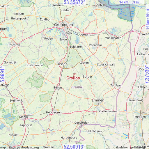
Grolloo GPS coordinates[2]
52° 56' 6" North, 6° 40' 19.992" East
| Map corner | latitude | longitude |
|---|---|---|
| Upper-left | 53.35672°, | 5.9691° |
| Center: | 52.935°, | 6.67222° |
| Lower-right: | 52.50913°, | 7.37535° |
| Map W x H: | 94.2×94.2 km | = 58.5×58.5mi |
| max Lat: | 53.48025° ⇑16.5% North |
| Grolloo: | 52.935° |
| min Lat: | ⇓83.5% South 50.76917° |
| min Long | Grolloo | max Long |
| 3.38611° | 6.67222° | 7.16528° |
| W 93%⇐ | ⇒7% E |
Elevation
Elevation of Grolloo is 20 m = 66 ft, and this is 5 m = 16 ft above average elevation for this country.
| Max E: |
203 m = 666 ft | 21.2% |
| Grolloo | 20 m 66 ft | |
| Avg. | 15 m = 49 ft | |
Min E: |
-6 m = -20 ft | 78.8% |
See also: Netherlands elevation on elevation.city.
Geographical zone
Grolloo is located in North temperate zone (between Tropic of Cancer and the Arctic Circle). Distance of this North polar circle is 1515.4 km =941.6 mi to North.| Distance of | km | miles | from Grolloo |
|---|---|---|---|
| North Pole | 4121.2 | 2560.8 | to North |
| Arctic Circle | 1515.4 | 941.6 | to North |
| Tropic Cancer | 3279.9 | 2038 | to South |
| Equator | 5885.8 | 3657.3 | to South |


Nearby cities:
15 places around Grolloo: (largest is in red/bold)
• Assen
10.1 km =6.3 mi,  313°
313°
• Beilen
13.3 km =8.3 mi,  233°
233°
• Borger
8.2 km =5.1 mi,  99°
99°
• Buinen
11 km =6.8 mi,  92°
92°
• Eext
10.1 km =6.3 mi,  24°
24°
• Gasselte
9.1 km =5.7 mi,  63°
63°
• Gasselternijveen
13.5 km =8.4 mi, 63°
• Gieten
9.9 km =6.2 mi,  38°
38°
• Hijken
12.5 km =7.8 mi,  249°
249°
• Hooghalen
9.1 km =5.7 mi,  260°
260°
• Marsdijk
10.9 km =6.8 mi,  327°
327°
• Peelo
11.7 km =7.3 mi,  321°
321°
• Rolde
5.7 km =3.5 mi,  343°
343°
• Schoonoord
11.4 km =7.1 mi,  150°
150°
• Westerbork
10.4 km =6.5 mi,  204°
204°
Sources, notices
• [Note1] Compared only with cities in Netherlands existing in our database
• [Src1] Map data: © OpenStreetMap contributors (CC-BY-SA)
• [Src2] Other city data from geonames.org with taken over terms of usage.
• [Src3] Geographical zone / Annual Mean Temperature by Robert A. Rohde @ Wikipedia
