Schiermonnikoog geodata
Schiermonnikoog (Friesland) is a seat of a second-order administrative division; located in Netherlands in Europe/Amsterdam (GMT+2) time zone. With population of 835 people, there are 1505 cities with bigger population in this country. Compared to other cities in Netherlands, 100% of cities are located further ↓South; 81.7% of cities are located further ←West and 54.1% of cities have higher elevation than Schiermonnikoog. Note1


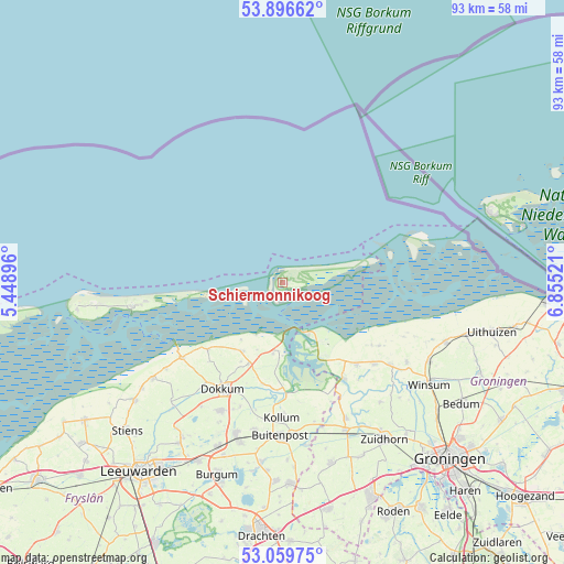
Schiermonnikoog GPS coordinates[2]
53° 28' 48.9" North, 6° 9' 7.524" East
| Map corner | latitude | longitude |
|---|---|---|
| Upper-left | 53.89662°, | 5.44896° |
| Center: | 53.48025°, | 6.15209° |
| Lower-right: | 53.05975°, | 6.85521° |
| Map W x H: | 93.1×93 km | = 57.8×57.8mi |
| max Lat: | 53.48025° ⇑0% North |
| Schiermonnikoog: | 53.48025° |
| min Lat: | ⇓100% South 50.76917° |
| min Long | Schiermonnikoog | max Long |
| 3.38611° | 6.15209° | 7.16528° |
| W 81.7%⇐ | ⇒18.3% E |
Elevation
Elevation of Schiermonnikoog is 5 m = 16 ft, and this is 10 m = 33 ft below average elevation for this country.
| Max E: |
203 m = 666 ft | 54.1% |
| Avg. | 15 m = 49 ft | |
| Schiermonnikoog | 5 m = 16 ft | |
Min E: |
-6 m = -20 ft | 45.9% |
See also: Netherlands elevation on elevation.city.
Geographical zone
Schiermonnikoog is located in North temperate zone (between Tropic of Cancer and the Arctic Circle). Distance of this North polar circle is 1454.7 km =903.9 mi to North.| Distance of | km | miles | from Schiermonnikoog |
|---|---|---|---|
| North Pole | 4060.6 | 2523.1 | to North |
| Arctic Circle | 1454.7 | 903.9 | to North |
| Tropic Cancer | 3340.5 | 2075.7 | to South |
| Equator | 5946.4 | 3694.9 | to South |


Nearby cities:
15 places around Schiermonnikoog: (largest is in red/bold)
• Anjum
11.8 km =7.3 mi,  188°
188°
• Dokkum
20.4 km =12.7 mi,  210°
210°
• Driezum
21.7 km =13.5 mi,  198°
198°
• Ee
17 km =10.6 mi, 191°
• Holwerd
20.8 km =12.9 mi,  233°
233°
• Kloosterburen
19 km =11.8 mi,  123°
123°
• Kollum
22.6 km =14 mi,  179°
179°
• Leens
20.1 km =12.5 mi,  131°
131°
• Metslawier
14.5 km =9 mi, 202°
• Oosternijkerk
13.1 km =8.1 mi, 209°
• Oudwoude
22.2 km =13.8 mi, 186°
• Ternaard
16.5 km =10.3 mi, 228°
• Ulrum
18 km =11.2 mi,  138°
138°
• Wâlterswâld
21.5 km =13.4 mi, 201°
• Zoutkamp
18.6 km =11.6 mi,  147°
147°
Sources, notices
• [Note1] Compared only with cities in Netherlands existing in our database
• [Src1] Map data: © OpenStreetMap contributors (CC-BY-SA)
• [Src2] Other city data from geonames.org with taken over terms of usage.
• [Src3] Geographical zone / Annual Mean Temperature by Robert A. Rohde @ Wikipedia
