Ternaard geodata
Ternaard (Friesland) is a populated place; located in Netherlands in Europe/Amsterdam (GMT+2) time zone. With population of 1,165 people, there are 1301 cities with bigger population in this country. Compared to other cities in Netherlands, 99.3% of cities are located further ↓South; 69.4% of cities are located further ←West and 74.9% of cities have higher elevation than Ternaard. Note1


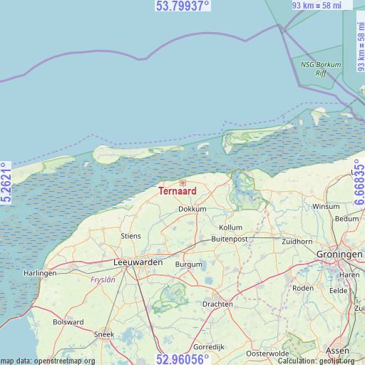
Ternaard GPS coordinates[2]
53° 22' 55.308" North, 5° 57' 54.828" East
| Map corner | latitude | longitude |
|---|---|---|
| Upper-left | 53.79937°, | 5.2621° |
| Center: | 53.38203°, | 5.96523° |
| Lower-right: | 52.96056°, | 6.66835° |
| Map W x H: | 93.3×93.3 km | = 58×58mi |
| max Lat: | 53.48025° ⇑0.7% North |
| Ternaard: | 53.38203° |
| min Lat: | ⇓99.3% South 50.76917° |
| min Long | Ternaard | max Long |
| 3.38611° | 5.96523° | 7.16528° |
| W 69.4%⇐ | ⇒30.6% E |
Elevation
Elevation of Ternaard is 2 m = 7 ft, and this is 13 m = 43 ft below average elevation for this country.
| Max E: |
203 m = 666 ft | 74.9% |
| Avg. | 15 m = 49 ft | |
| Ternaard | 2 m = 7 ft | |
Min E: |
-6 m = -20 ft | 25.1% |
See also: Netherlands elevation on elevation.city.
Geographical zone
Ternaard is located in North temperate zone (between Tropic of Cancer and the Arctic Circle). Distance of this North polar circle is 1465.6 km =910.7 mi to North.| Distance of | km | miles | from Ternaard |
|---|---|---|---|
| North Pole | 4071.5 | 2529.9 | to North |
| Arctic Circle | 1465.6 | 910.7 | to North |
| Tropic Cancer | 3329.6 | 2068.9 | to South |
| Equator | 5935.5 | 3688.1 | to South |


Nearby cities:
15 places around Ternaard: (largest is in red/bold)
• Anjum
10.8 km =6.7 mi,  94°
94°
• Blije
7.7 km =4.8 mi,  244°
244°
• Broeksterwâld
12.1 km =7.5 mi,  170°
170°
• Burdaard
11.3 km =7 mi,  210°
210°
• Damwâld
10.4 km =6.5 mi, 167°
• Dokkum
7 km =4.3 mi,  162°
162°
• Driezum
11 km =6.8 mi,  150°
150°
• Ee
10.7 km =6.6 mi,  122°
122°
• Ferwert
10.5 km =6.5 mi, 242°
• Holwerd
4.5 km =2.8 mi,  250°
250°
• Marrum
12.7 km =7.9 mi, 238°
• Metslawier
7.2 km =4.5 mi,  110°
110°
• Oosternijkerk
5.9 km =3.7 mi, 93°
• Rinsumageast
9.5 km =5.9 mi,  186°
186°
• Wâlterswâld
10.2 km =6.3 mi, 153°
Sources, notices
• [Note1] Compared only with cities in Netherlands existing in our database
• [Src1] Map data: © OpenStreetMap contributors (CC-BY-SA)
• [Src2] Other city data from geonames.org with taken over terms of usage.
• [Src3] Geographical zone / Annual Mean Temperature by Robert A. Rohde @ Wikipedia
