Oudkarspel geodata
Oudkarspel (North Holland) is a populated place; located in Netherlands in Europe/Amsterdam (GMT+2) time zone. With population of 3,170 people, there are 731 cities with bigger population in this country. Compared to other cities in Netherlands, 77% of cities are located further ↓South; 79.4% of cities are located further →East and 96.1% of cities have higher elevation than Oudkarspel. Note1


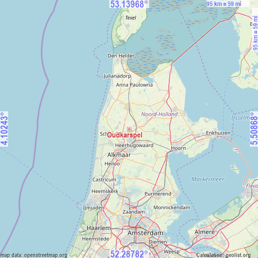
Oudkarspel GPS coordinates[2]
52° 42' 56.988" North, 4° 48' 20.016" East
| Map corner | latitude | longitude |
|---|---|---|
| Upper-left | 53.13968°, | 4.10243° |
| Center: | 52.71583°, | 4.80556° |
| Lower-right: | 52.28782°, | 5.50868° |
| Map W x H: | 94.7×94.7 km | = 58.8×58.8mi |
| max Lat: | 53.48025° ⇑23% North |
| Oudkarspel: | 52.71583° |
| min Lat: | ⇓77% South 50.76917° |
| min Long | Oudkarspel | max Long |
| 3.38611° | 4.80556° | 7.16528° |
| W 20.6%⇐ | ⇒79.4% E |
Elevation
Elevation of Oudkarspel is -1 m = -3 ft, and this is 16 m = 52 ft below average elevation for this country.
| Max E: |
203 m = 666 ft | 96.1% |
| Avg. | 15 m = 49 ft | |
| Oudkarspel | -1 m = -3 ft | |
Min E: |
-6 m = -20 ft | 3.9% |
See also: Netherlands elevation on elevation.city.
Geographical zone
Oudkarspel is located in North temperate zone (between Tropic of Cancer and the Arctic Circle). Distance of this North polar circle is 1539.7 km =956.7 mi to North.| Distance of | km | miles | from Oudkarspel |
|---|---|---|---|
| North Pole | 4145.6 | 2576 | to North |
| Arctic Circle | 1539.7 | 956.7 | to North |
| Tropic Cancer | 3255.5 | 2022.9 | to South |
| Equator | 5861.5 | 3642.2 | to South |


Nearby cities:
15 places around Oudkarspel: (largest is in red/bold)
• Aagtdorp
7.4 km =4.6 mi,  247°
247°
• Broek op Langedijk
4.6 km =2.9 mi,  180°
180°
• Burgerbrug
7.8 km =4.8 mi,  297°
297°
• De Noord
3.2 km =2 mi,  106°
106°
• Dirkshorn
4.3 km =2.7 mi,  331°
331°
• Harenkarspel
2.8 km =1.7 mi,  316°
316°
• Heerhugowaard
5.7 km =3.5 mi,  149°
149°
• Nieuwe-Niedorp
6.8 km =4.2 mi,  66°
66°
• Noord-Scharwoude
2 km =1.2 mi,  169°
169°
• Schagen
8 km =5 mi,  356°
356°
• Sint Maarten
7.5 km =4.7 mi, 327°
• Sint Pancras
6.4 km =4 mi,  193°
193°
• Waarland
2.1 km =1.3 mi,  55°
55°
• Winkel
7.8 km =4.8 mi, 56°
• Zuid-Scharwoude
3.2 km =2 mi, 176°
Sources, notices
• [Note1] Compared only with cities in Netherlands existing in our database
• [Src1] Map data: © OpenStreetMap contributors (CC-BY-SA)
• [Src2] Other city data from geonames.org with taken over terms of usage.
• [Src3] Geographical zone / Annual Mean Temperature by Robert A. Rohde @ Wikipedia
