Ravenstein geodata
Ravenstein (North Brabant) is a populated place; located in Netherlands in Europe/Amsterdam (GMT+2) time zone. With population of 1,465 people, there are 1154 cities with bigger population in this country. Compared to other cities in Netherlands, 64.8% of cities are located further ↑North; 50.2% of cities are located further →East and 64.6% of cities have lower elevation than Ravenstein. Note1


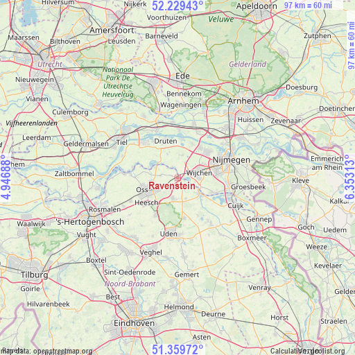
Ravenstein GPS coordinates[2]
51° 47' 48.012" North, 5° 39' 0" East
| Map corner | latitude | longitude |
|---|---|---|
| Upper-left | 52.22943°, | 4.94688° |
| Center: | 51.79667°, | 5.65° |
| Lower-right: | 51.35972°, | 6.35313° |
| Map W x H: | 96.7×96.7 km | = 60.1×60.1mi |
| max Lat: | 53.48025° ⇑64.8% North |
| Ravenstein: | 51.79667° |
| min Lat: | ⇓35.2% South 50.76917° |
| min Long | Ravenstein | max Long |
| 3.38611° | 5.65° | 7.16528° |
| W 49.8%⇐ | ⇒50.2% E |
Elevation
Elevation of Ravenstein is 12 m = 39 ft, and this is 3 m = 10 ft below average elevation for this country.
| Max E: |
203 m = 666 ft | 35.4% |
| Avg. | 15 m = 49 ft | |
| Ravenstein | 12 m = 39 ft | |
Min E: |
-6 m = -20 ft | 64.6% |
See also: Netherlands elevation on elevation.city.
Geographical zone
Ravenstein is located in North temperate zone (between Tropic of Cancer and the Arctic Circle). Distance of this North polar circle is 1641.9 km =1020.2 mi to North.| Distance of | km | miles | from Ravenstein |
|---|---|---|---|
| North Pole | 4247.8 | 2639.5 | to North |
| Arctic Circle | 1641.9 | 1020.2 | to North |
| Tropic Cancer | 3153.3 | 1959.4 | to South |
| Equator | 5759.2 | 3578.6 | to South |


Nearby cities:
15 places around Ravenstein: (largest is in red/bold)
• Batenburg
3.4 km =2.1 mi,  334°
334°
• Bergharen
6.2 km =3.9 mi,  12°
12°
• Berghem
6.4 km =4 mi,  242°
242°
• Grave
7.4 km =4.6 mi,  124°
124°
• Haren
4.5 km =2.8 mi,  277°
277°
• Hernen
4.7 km =2.9 mi,  26°
26°
• Herpen
2.8 km =1.7 mi,  191°
191°
• Horssen
7.1 km =4.4 mi,  337°
337°
• Macharen
7.3 km =4.5 mi, 277°
• Megen
6.6 km =4.1 mi,  294°
294°
• Nederasselt
7.1 km =4.4 mi,  113°
113°
• Reek
6.1 km =3.8 mi,  158°
158°
• Schaijk
5.8 km =3.6 mi, 192°
• Valendries
5.9 km =3.7 mi,  79°
79°
• Wijchen
5.3 km =3.3 mi,  74°
74°
Sources, notices
• [Note1] Compared only with cities in Netherlands existing in our database
• [Src1] Map data: © OpenStreetMap contributors (CC-BY-SA)
• [Src2] Other city data from geonames.org with taken over terms of usage.
• [Src3] Geographical zone / Annual Mean Temperature by Robert A. Rohde @ Wikipedia
