Hernen geodata
Hernen (Gelderland) is a populated place; located in Netherlands in Europe/Amsterdam (GMT+2) time zone. With population of 700 people, there are 1626 cities with bigger population in this country. Compared to other cities in Netherlands, 62.1% of cities are located further ↑North; 51.2% of cities are located further ←West and 57.3% of cities have lower elevation than Hernen. Note1


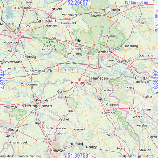
Hernen GPS coordinates[2]
51° 50' 3.012" North, 5° 40' 50.016" East
| Map corner | latitude | longitude |
|---|---|---|
| Upper-left | 52.26657°, | 4.97744° |
| Center: | 51.83417°, | 5.68056° |
| Lower-right: | 51.39758°, | 6.38369° |
| Map W x H: | 96.6×96.6 km | = 60×60mi |
| max Lat: | 53.48025° ⇑62.1% North |
| Hernen: | 51.83417° |
| min Lat: | ⇓37.9% South 50.76917° |
| min Long | Hernen | max Long |
| 3.38611° | 5.68056° | 7.16528° |
| W 51.2%⇐ | ⇒48.8% E |
Elevation
Elevation of Hernen is 9 m = 30 ft, and this is 6 m = 20 ft below average elevation for this country.
| Max E: |
203 m = 666 ft | 42.7% |
| Avg. | 15 m = 49 ft | |
| Hernen | 9 m = 30 ft | |
Min E: |
-6 m = -20 ft | 57.3% |
See also: Netherlands elevation on elevation.city.
Geographical zone
Hernen is located in North temperate zone (between Tropic of Cancer and the Arctic Circle). Distance of this North polar circle is 1637.8 km =1017.7 mi to North.| Distance of | km | miles | from Hernen |
|---|---|---|---|
| North Pole | 4243.6 | 2636.8 | to North |
| Arctic Circle | 1637.8 | 1017.7 | to North |
| Tropic Cancer | 3157.5 | 1962 | to South |
| Equator | 5763.4 | 3581.2 | to South |


Nearby cities:
15 places around Hernen: (largest is in red/bold)
• Afferden
6 km =3.7 mi,  328°
328°
• Alverna
6.4 km =4 mi,  121°
121°
• Batenburg
3.7 km =2.3 mi,  252°
252°
• Bergharen
2 km =1.2 mi,  337°
337°
• Beuningen
6.6 km =4.1 mi,  63°
63°
• Deest
6.3 km =3.9 mi,  351°
351°
• Druten
7.9 km =4.9 mi,  319°
319°
• Haren
7.5 km =4.7 mi,  241°
241°
• Herpen
7.4 km =4.6 mi,  201°
201°
• Horssen
5.4 km =3.4 mi,  296°
296°
• Lindenholt
7.8 km =4.8 mi,  91°
91°
• Puiflijk
7.9 km =4.9 mi,  308°
308°
• Ravenstein
4.7 km =2.9 mi,  206°
206°
• Valendries
4.8 km =3 mi,  129°
129°
• Wijchen
4.1 km =2.5 mi, 132°
Sources, notices
• [Note1] Compared only with cities in Netherlands existing in our database
• [Src1] Map data: © OpenStreetMap contributors (CC-BY-SA)
• [Src2] Other city data from geonames.org with taken over terms of usage.
• [Src3] Geographical zone / Annual Mean Temperature by Robert A. Rohde @ Wikipedia
