Oterleek geodata
Oterleek (North Holland) is a populated place; located in Netherlands in Europe/Amsterdam (GMT+2) time zone. With population of 620 people, there are 1702 cities with bigger population in this country. Compared to other cities in Netherlands, 74.4% of cities are located further ↓South; 78.2% of cities are located further →East and 83.9% of cities have higher elevation than Oterleek. Note1


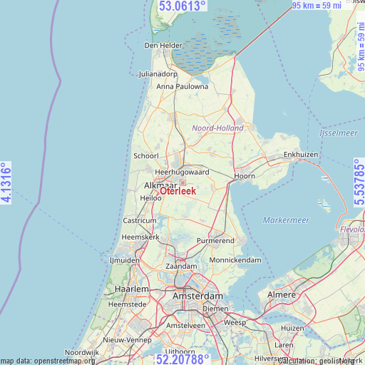
Oterleek GPS coordinates[2]
52° 38' 12.012" North, 4° 50' 4.992" East
| Map corner | latitude | longitude |
|---|---|---|
| Upper-left | 53.0613°, | 4.1316° |
| Center: | 52.63667°, | 4.83472° |
| Lower-right: | 52.20788°, | 5.53785° |
| Map W x H: | 94.9×94.9 km | = 59×59mi |
| max Lat: | 53.48025° ⇑25.6% North |
| Oterleek: | 52.63667° |
| min Lat: | ⇓74.4% South 50.76917° |
| min Long | Oterleek | max Long |
| 3.38611° | 4.83472° | 7.16528° |
| W 21.8%⇐ | ⇒78.2% E |
Elevation
Elevation of Oterleek is 1 m = 3 ft, and this is 14 m = 46 ft below average elevation for this country.
| Max E: |
203 m = 666 ft | 83.9% |
| Avg. | 15 m = 49 ft | |
| Oterleek | 1 m = 3 ft | |
Min E: |
-6 m = -20 ft | 16.1% |
See also: Netherlands elevation on elevation.city.
Geographical zone
Oterleek is located in North temperate zone (between Tropic of Cancer and the Arctic Circle). Distance of this North polar circle is 1548.5 km =962.2 mi to North.| Distance of | km | miles | from Oterleek |
|---|---|---|---|
| North Pole | 4154.4 | 2581.4 | to North |
| Arctic Circle | 1548.5 | 962.2 | to North |
| Tropic Cancer | 3246.7 | 2017.4 | to South |
| Equator | 5852.6 | 3636.6 | to South |


Nearby cities:
15 places around Oterleek: (largest is in red/bold)
• Alkmaar
5.8 km =3.6 mi,  264°
264°
• Broek op Langedijk
4.6 km =2.9 mi,  334°
334°
• De Goorn
7.7 km =4.8 mi,  99°
99°
• De Noord
8 km =5 mi,  8°
8°
• Grootschermer
6.1 km =3.8 mi,  170°
170°
• Heerhugowaard
4 km =2.5 mi, 13°
• Hensbroek
4.1 km =2.5 mi,  54°
54°
• Noord-Scharwoude
7 km =4.3 mi,  346°
346°
• Obdam
6.5 km =4 mi, 48°
• Schermerhorn
5.5 km =3.4 mi,  136°
136°
• Sint Pancras
4.3 km =2.7 mi,  306°
306°
• Spierdijk
7.5 km =4.7 mi,  77°
77°
• Stompetoren
2.8 km =1.7 mi,  199°
199°
• Zuid-Scharwoude
5.8 km =3.6 mi,  342°
342°
• Zuidschermer
6.9 km =4.3 mi,  213°
213°
Sources, notices
• [Note1] Compared only with cities in Netherlands existing in our database
• [Src1] Map data: © OpenStreetMap contributors (CC-BY-SA)
• [Src2] Other city data from geonames.org with taken over terms of usage.
• [Src3] Geographical zone / Annual Mean Temperature by Robert A. Rohde @ Wikipedia
