Heerhugowaard geodata
Heerhugowaard (North Holland) is a populated place; located in Netherlands in Europe/Amsterdam (GMT+2) time zone. With population of 47,580 people, there are 64 cities with bigger population in this country. Compared to other cities in Netherlands, 75.4% of cities are located further ↓South; 78% of cities are located further →East and 96.1% of cities have higher elevation than Heerhugowaard. Note1


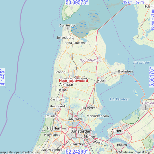
Heerhugowaard GPS coordinates[2]
52° 40' 17.184" North, 4° 50' 55.032" East
| Map corner | latitude | longitude |
|---|---|---|
| Upper-left | 53.09573°, | 4.1455° |
| Center: | 52.67144°, | 4.84862° |
| Lower-right: | 52.24299°, | 5.55175° |
| Map W x H: | 94.8×94.8 km | = 58.9×58.9mi |
| max Lat: | 53.48025° ⇑24.6% North |
| Heerhugowaard: | 52.67144° |
| min Lat: | ⇓75.4% South 50.76917° |
| min Long | Heerhugowaard | max Long |
| 3.38611° | 4.84862° | 7.16528° |
| W 22%⇐ | ⇒78% E |
Elevation
Elevation of Heerhugowaard is -1 m = -3 ft, and this is 16 m = 52 ft below average elevation for this country.
| Max E: |
203 m = 666 ft | 96.1% |
| Avg. | 15 m = 49 ft | |
| Heerhugowaard | -1 m = -3 ft | |
Min E: |
-6 m = -20 ft | 3.9% |
See also: Heerhugowaard elevation on elevation.city.
Geographical zone
Heerhugowaard is located in North temperate zone (between Tropic of Cancer and the Arctic Circle). Distance of this North polar circle is 1544.7 km =959.8 mi to North.| Distance of | km | miles | from Heerhugowaard |
|---|---|---|---|
| North Pole | 4150.5 | 2579 | to North |
| Arctic Circle | 1544.7 | 959.8 | to North |
| Tropic Cancer | 3250.6 | 2019.8 | to South |
| Equator | 5856.5 | 3639.1 | to South |


Nearby cities:
15 places around Heerhugowaard: (largest is in red/bold)
• Alkmaar
8.1 km =5 mi,  236°
236°
• Broek op Langedijk
2.9 km =1.8 mi,  275°
275°
• De Noord
4 km =2.5 mi,  2°
2°
• Hensbroek
2.8 km =1.7 mi,  120°
120°
• Hoogwoud
7.8 km =4.8 mi,  50°
50°
• Noord-Scharwoude
3.9 km =2.4 mi,  319°
319°
• Obdam
4 km =2.5 mi,  82°
82°
• Opmeer
7.6 km =4.7 mi,  58°
58°
• Oterleek
4 km =2.5 mi,  193°
193°
• Oudkarspel
5.7 km =3.5 mi,  329°
329°
• Sint Pancras
4.6 km =2.9 mi,  253°
253°
• Spierdijk
6.8 km =4.2 mi,  109°
109°
• Stompetoren
6.7 km =4.2 mi,  196°
196°
• Waarland
6.2 km =3.9 mi,  349°
349°
• Zuid-Scharwoude
3.2 km =2 mi,  301°
301°
Sources, notices
• [Note1] Compared only with cities in Netherlands existing in our database
• [Src1] Map data: © OpenStreetMap contributors (CC-BY-SA)
• [Src2] Other city data from geonames.org with taken over terms of usage.
• [Src3] Geographical zone / Annual Mean Temperature by Robert A. Rohde @ Wikipedia
