Nes geodata
Nes (Friesland) is a populated place; located in Netherlands in Europe/Amsterdam (GMT+2) time zone. With population of 1,140 people, there are 1307 cities with bigger population in this country. Compared to other cities in Netherlands, 99.9% of cities are located further ↓South; 56% of cities are located further ←West and 54.1% of cities have higher elevation than Nes. Note1


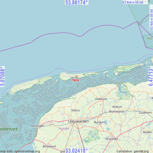
Nes GPS coordinates[2]
53° 26' 42.072" North, 5° 46' 26.4" East
| Map corner | latitude | longitude |
|---|---|---|
| Upper-left | 53.86174°, | 5.07088° |
| Center: | 53.44502°, | 5.774° |
| Lower-right: | 53.02418°, | 6.47713° |
| Map W x H: | 93.1×93.1 km | = 57.8×57.8mi |
| max Lat: | 53.48025° ⇑0.1% North |
| Nes: | 53.44502° |
| min Lat: | ⇓99.9% South 50.76917° |
| min Long | Nes | max Long |
| 3.38611° | 5.774° | 7.16528° |
| W 56%⇐ | ⇒44% E |
Elevation
Elevation of Nes is 5 m = 16 ft, and this is 10 m = 33 ft below average elevation for this country.
| Max E: |
203 m = 666 ft | 54.1% |
| Avg. | 15 m = 49 ft | |
| Nes | 5 m = 16 ft | |
Min E: |
-6 m = -20 ft | 45.9% |
See also: Netherlands elevation on elevation.city.
Geographical zone
Nes is located in North temperate zone (between Tropic of Cancer and the Arctic Circle). Distance of this North polar circle is 1458.6 km =906.3 mi to North.| Distance of | km | miles | from Nes |
|---|---|---|---|
| North Pole | 4064.5 | 2525.6 | to North |
| Arctic Circle | 1458.6 | 906.3 | to North |
| Tropic Cancer | 3336.6 | 2073.3 | to South |
| Equator | 5942.5 | 3692.5 | to South |


Nearby cities:
15 places around Nes: (largest is in red/bold)
• Blije
11.9 km =7.4 mi,  150°
150°
• Burdaard
18.2 km =11.3 mi,  157°
157°
• Buren
1.7 km =1.1 mi,  81°
81°
• Dokkum
20.1 km =12.5 mi,  132°
132°
• Ferwert
12.4 km =7.7 mi, 164°
• Hallum
15.4 km =9.6 mi,  177°
177°
• Hollum
9 km =5.6 mi,  266°
266°
• Holwerd
12 km =7.5 mi,  135°
135°
• Marrum
13.7 km =8.5 mi,  172°
172°
• Oosternijkerk
19.9 km =12.4 mi,  111°
111°
• Oude Bildtzijl
16.5 km =10.3 mi,  192°
192°
• Rinsumageast
20.2 km =12.6 mi, 144°
• Stiens
20.3 km =12.6 mi, 183°
• Ternaard
14.5 km =9 mi,  118°
118°
• Vrouwenparochie
19.1 km =11.9 mi, 194°
Sources, notices
• [Note1] Compared only with cities in Netherlands existing in our database
• [Src1] Map data: © OpenStreetMap contributors (CC-BY-SA)
• [Src2] Other city data from geonames.org with taken over terms of usage.
• [Src3] Geographical zone / Annual Mean Temperature by Robert A. Rohde @ Wikipedia
